Boyne Island geodata
Boyne Island (Queensland) is a populated place; located in Australia in Australia/Brisbane (GMT+10) time zone. With population of 4,685 people, there are 1574 cities with bigger population in this country. Compared to other cities in Australia, 90.8% of cities are located further ↓South; 76.5% of cities are located further ←West and 70.9% of cities have higher elevation than Boyne Island. Note1


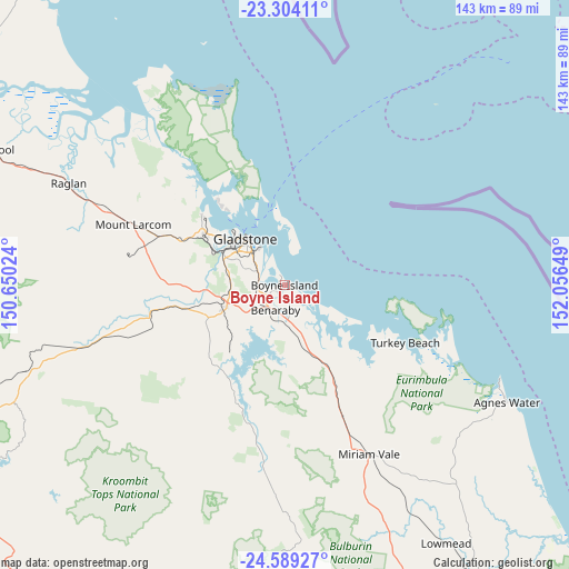
Boyne Island GPS coordinates[2]
23° 56' 53.844" South, 151° 21' 12.096" East
| Map corner | latitude | longitude |
|---|---|---|
| Upper-left | -23.30411°, | 150.65024° |
| Center: | -23.94829°, | 151.35336° |
| Lower-right: | -24.58927°, | 152.05649° |
| Map W x H: | 142.9×142.9 km | = 88.8×88.8mi |
| max Lat: | -10.58257° ⇑9.2% North |
| Boyne Island: | -23.94829° |
| min Lat: | ⇓90.8% South -43.31423° |
| min Long | Boyne Island | max Long |
| 113.53327° | 151.35336° | 153.61246° |
| W 76.5%⇐ | ⇒23.5% E |
Elevation
Elevation of Boyne Island is 22 m = 72 ft, and this is 100 m = 328 ft below average elevation for this country.
| Max E: |
1715 m = 5627 ft | 70.9% |
| Avg. | 122 m = 400 ft | |
| Boyne Island | 22 m = 72 ft | |
Min E: |
-2 m = -7 ft | 29.1% |
See also: Australia elevation on elevation.city.
Geographical zone
Boyne Island is located in South temperate zone (between Tropic of Capricorn and the Antarctic Circle). Distance of this Southern Tropic circle is 56.9 km =35.4 mi to North.| Distance of | km | miles | from Boyne Island |
|---|---|---|---|
| Equator | 2662.8 | 1654.6 | to North |
| Tropic Capricorn | 56.9 | 35.4 | to North |
| Antarctic Circle | 4738.4 | 2944.3 | to South |
| South Pole | 7344.3 | 4563.5 | to South |


Nearby cities:
15 places around Boyne Island: (largest is in red/bold)
• Barney Point
14.3 km =8.9 mi,  321°
321°
• Benaraby
6.5 km =4 mi,  197°
197°
• Burua
13.9 km =8.6 mi,  269°
269°
• Gladstone
14.7 km =9.1 mi, 318°
• Gladstone Central
15.8 km =9.8 mi, 317°
• Glen Eden
10.1 km =6.3 mi,  304°
304°
• Kin Kora
13.4 km =8.3 mi,  306°
306°
• Kirkwood
13 km =8.1 mi,  292°
292°
• New Auckland
14 km =8.7 mi, 301°
• South Gladstone
12.9 km =8 mi, 317°
• Sun Valley
12.7 km =7.9 mi, 309°
• Tannum Sands
1.4 km =0.9 mi,  86°
86°
• Telina
12.1 km =7.5 mi, 303°
• Toolooa
11.2 km =7 mi, 308°
• West Gladstone
14.6 km =9.1 mi, 311°
Sources, notices
• [Note1] Compared only with cities in Australia existing in our database
• [Src1] Map data: © OpenStreetMap contributors (CC-BY-SA)
• [Src2] Other city data from geonames.org with taken over terms of usage.
• [Src3] Geographical zone / Annual Mean Temperature by Robert A. Rohde @ Wikipedia
