Thornton geodata
Thornton (New South Wales) is a section of populated place; located in Australia in Australia/Sydney (GMT+11) time zone. With population of 7,879 people, there are 846 cities with bigger population in this country. Compared to other cities in Australia, 59.9% of cities are located further ↓South; 79.4% of cities are located further ←West and 70.9% of cities have higher elevation than Thornton. Note1


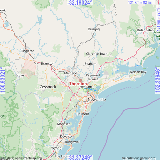
Thornton GPS coordinates[2]
32° 46' 59.988" South, 151° 37' 59.988" East
| Map corner | latitude | longitude |
|---|---|---|
| Upper-left | -32.19024°, | 150.93021° |
| Center: | -32.78333°, | 151.63333° |
| Lower-right: | -33.37249°, | 152.33646° |
| Map W x H: | 131.5×131.5 km | = 81.7×81.7mi |
| max Lat: | -10.58257° ⇑40.1% North |
| Thornton: | -32.78333° |
| min Lat: | ⇓59.9% South -43.31423° |
| min Long | Thornton | max Long |
| 113.53327° | 151.63333° | 153.61246° |
| W 79.4%⇐ | ⇒20.6% E |
Elevation
Elevation of Thornton is 22 m = 72 ft, and this is 100 m = 328 ft below average elevation for this country.
| Max E: |
1715 m = 5627 ft | 70.9% |
| Avg. | 122 m = 400 ft | |
| Thornton | 22 m = 72 ft | |
Min E: |
-2 m = -7 ft | 29.1% |
See also: Australia elevation on elevation.city.
Geographical zone
Thornton is located in South temperate zone (between Tropic of Capricorn and the Antarctic Circle). Distance of this Southern Tropic circle is 1039.2 km =645.7 mi to North.| Distance of | km | miles | from Thornton |
|---|---|---|---|
| Equator | 3645.2 | 2265 | to North |
| Tropic Capricorn | 1039.2 | 645.7 | to North |
| Antarctic Circle | 3756 | 2333.9 | to South |
| South Pole | 6361.9 | 3953.1 | to South |


Nearby cities:
15 places around Thornton: (largest is in red/bold)
• Ashtonfield
2.8 km =1.7 mi,  293°
293°
• Beresfield
2.4 km =1.5 mi,  139°
139°
• Black Hill
6.2 km =3.9 mi,  192°
192°
• East Maitland
6 km =3.7 mi,  308°
308°
• Heatherbrae
9.6 km =6 mi,  93°
93°
• Lorn
8.5 km =5.3 mi,  317°
317°
• Louth Park
8.1 km =5 mi,  279°
279°
• Maitland
9 km =5.6 mi, 308°
• Maitland city centre
9.4 km =5.8 mi, 306°
• Metford
3 km =1.9 mi, 312°
• Morpeth
5.6 km =3.5 mi,  0°
0°
• Raworth
5.8 km =3.6 mi,  344°
344°
• Tarro
3.6 km =2.2 mi,  120°
120°
• Tenambit
5.2 km =3.2 mi, 338°
• Woodberry
4.2 km =2.6 mi,  104°
104°
Sources, notices
• [Note1] Compared only with cities in Australia existing in our database
• [Src1] Map data: © OpenStreetMap contributors (CC-BY-SA)
• [Src2] Other city data from geonames.org with taken over terms of usage.
• [Src3] Geographical zone / Annual Mean Temperature by Robert A. Rohde @ Wikipedia
