Tarro geodata
Tarro (New South Wales) is a populated place; located in Australia in Australia/Sydney (GMT+11) time zone. With population of 1,636 people, there are 3154 cities with bigger population in this country. Compared to other cities in Australia, 59.7% of cities are located further ↓South; 80% of cities are located further ←West and 100% of cities have higher elevation than Tarro. Note1


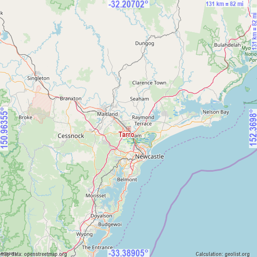
Tarro GPS coordinates[2]
32° 48' 0" South, 151° 40' 0.012" East
| Map corner | latitude | longitude |
|---|---|---|
| Upper-left | -32.20702°, | 150.96355° |
| Center: | -32.8°, | 151.66667° |
| Lower-right: | -33.38905°, | 152.3698° |
| Map W x H: | 131.4×131.4 km | = 81.6×81.6mi |
| max Lat: | -10.58257° ⇑40.3% North |
| Tarro: | -32.8° |
| min Lat: | ⇓59.7% South -43.31423° |
| min Long | Tarro | max Long |
| 113.53327° | 151.66667° | 153.61246° |
| W 80%⇐ | ⇒20% E |
Elevation
Elevation of Tarro is 0 m = 0 ft, and this is 122 m = 400 ft below average elevation for this country.
| Max E: |
1715 m = 5627 ft | 100% |
| Avg. | 122 m = 400 ft | |
| Tarro | 0 m = 0 ft | |
Min E: |
-2 m = -7 ft | 0% |
See also: Australia elevation on elevation.city.
Geographical zone
Tarro is located in South temperate zone (between Tropic of Capricorn and the Antarctic Circle). Distance of this Southern Tropic circle is 1041.1 km =646.9 mi to North.| Distance of | km | miles | from Tarro |
|---|---|---|---|
| Equator | 3647 | 2266.1 | to North |
| Tropic Capricorn | 1041.1 | 646.9 | to North |
| Antarctic Circle | 3754.2 | 2332.8 | to South |
| South Pole | 6360 | 3951.9 | to South |


Nearby cities:
15 places around Tarro: (largest is in red/bold)
• Ashtonfield
6.4 km =4 mi,  297°
297°
• Beresfield
1.6 km =1 mi,  270°
270°
• Black Hill
6.1 km =3.8 mi,  226°
226°
• Fletcher
8.4 km =5.2 mi,  197°
197°
• Heatherbrae
6.5 km =4 mi,  79°
79°
• Maryland
8.8 km =5.5 mi,  183°
183°
• Metford
6.6 km =4.1 mi,  306°
306°
• Morpeth
8 km =5 mi,  337°
337°
• Nelsons Plains
8.6 km =5.3 mi,  47°
47°
• Raworth
8.8 km =5.5 mi,  327°
327°
• Raymond Terrace
9 km =5.6 mi,  60°
60°
• Shortland
9.1 km =5.7 mi,  165°
165°
• Tenambit
8.4 km =5.2 mi,  323°
323°
• Thornton
3.6 km =2.2 mi, 300°
• Woodberry
1.2 km =0.7 mi, 51°
Sources, notices
• [Note1] Compared only with cities in Australia existing in our database
• [Src1] Map data: © OpenStreetMap contributors (CC-BY-SA)
• [Src2] Other city data from geonames.org with taken over terms of usage.
• [Src3] Geographical zone / Annual Mean Temperature by Robert A. Rohde @ Wikipedia
