Tallebudgera geodata
Tallebudgera (Queensland) is a section of populated place; located in Australia in Australia/Brisbane (GMT+10) time zone. With population of 3,614 people, there are 1950 cities with bigger population in this country. Compared to other cities in Australia, 75.3% of cities are located further ↓South; 99% of cities are located further ←West and 83.5% of cities have higher elevation than Tallebudgera. Note1


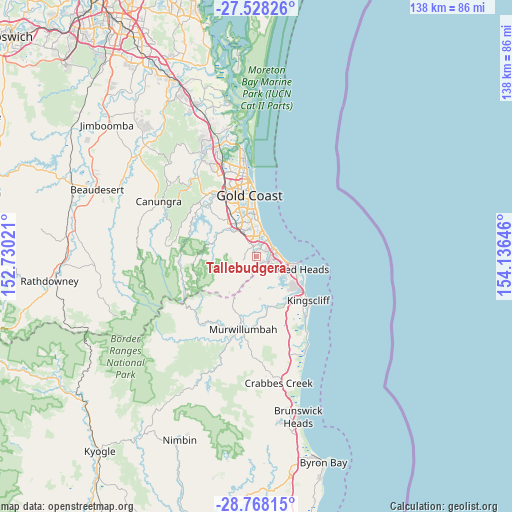
Tallebudgera GPS coordinates[2]
28° 9' 0" South, 153° 25' 59.988" East
| Map corner | latitude | longitude |
|---|---|---|
| Upper-left | -27.52826°, | 152.73021° |
| Center: | -28.15°, | 153.43333° |
| Lower-right: | -28.76815°, | 154.13646° |
| Map W x H: | 137.9×137.9 km | = 85.7×85.7mi |
| max Lat: | -10.58257° ⇑24.7% North |
| Tallebudgera: | -28.15° |
| min Lat: | ⇓75.3% South -43.31423° |
| min Long | Tallebudgera | max Long |
| 113.53327° | 153.43333° | 153.61246° |
| W 99%⇐ | ⇒1% E |
Elevation
Elevation of Tallebudgera is 13 m = 43 ft, and this is 109 m = 358 ft below average elevation for this country.
| Max E: |
1715 m = 5627 ft | 83.5% |
| Avg. | 122 m = 400 ft | |
| Tallebudgera | 13 m = 43 ft | |
Min E: |
-2 m = -7 ft | 16.5% |
See also: Australia elevation on elevation.city.
Geographical zone
Tallebudgera is located in South temperate zone (between Tropic of Capricorn and the Antarctic Circle). Distance of this Southern Tropic circle is 524.1 km =325.7 mi to North.| Distance of | km | miles | from Tallebudgera |
|---|---|---|---|
| Equator | 3130 | 1944.9 | to North |
| Tropic Capricorn | 524.1 | 325.7 | to North |
| Antarctic Circle | 4271.2 | 2654 | to South |
| South Pole | 6877.1 | 4273.2 | to South |


Nearby cities:
15 places around Tallebudgera: (largest is in red/bold)
• Bilambil Heights
8.9 km =5.5 mi,  145°
145°
• Bilinga
8.4 km =5.2 mi,  102°
102°
• Bonogin
8 km =5 mi,  278°
278°
• Burleigh Heads
5.8 km =3.6 mi,  16°
16°
• Burleigh Waters
5.7 km =3.5 mi,  351°
351°
• Currumbin
5 km =3.1 mi,  72°
72°
• Currumbin Valley
7.5 km =4.7 mi,  210°
210°
• Currumbin Waters
3.9 km =2.4 mi, 97°
• Elanora
2.2 km =1.4 mi,  44°
44°
• Miami
8.7 km =5.4 mi,  5°
5°
• Palm Beach
4.9 km =3 mi, 40°
• Reedy Creek
5.5 km =3.4 mi,  319°
319°
• Tallebudgera Valley
9 km =5.6 mi,  238°
238°
• Tugun
6.5 km =4 mi,  90°
90°
• Varsity Lakes
7 km =4.3 mi,  342°
342°
Sources, notices
• [Note1] Compared only with cities in Australia existing in our database
• [Src1] Map data: © OpenStreetMap contributors (CC-BY-SA)
• [Src2] Other city data from geonames.org with taken over terms of usage.
• [Src3] Geographical zone / Annual Mean Temperature by Robert A. Rohde @ Wikipedia
