Tallebudgera Valley geodata
Tallebudgera Valley (Queensland) is a section of populated place; located in Australia in Australia/Brisbane (GMT+10) time zone. With population of 1,637 people, there are 3153 cities with bigger population in this country. Compared to other cities in Australia, 75.2% of cities are located further ↓South; 98.1% of cities are located further ←West and 72.3% of cities have lower elevation than Tallebudgera Valley. Note1


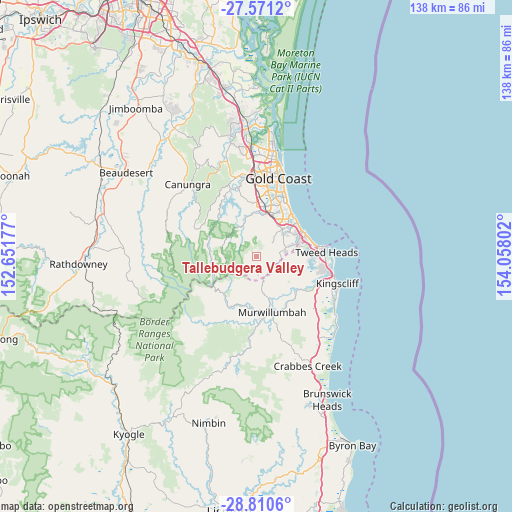
Tallebudgera Valley GPS coordinates[2]
28° 11' 33.72" South, 153° 21' 17.604" East
| Map corner | latitude | longitude |
|---|---|---|
| Upper-left | -27.5712°, | 152.65177° |
| Center: | -28.1927°, | 153.35489° |
| Lower-right: | -28.8106°, | 154.05802° |
| Map W x H: | 137.8×137.8 km | = 85.6×85.6mi |
| max Lat: | -10.58257° ⇑24.8% North |
| Tallebudgera Valley: | -28.1927° |
| min Lat: | ⇓75.2% South -43.31423° |
| min Long | Tallebudgera Va | max Long |
| 113.53327° | 153.35489° | 153.61246° |
| W 98.1%⇐ | ⇒1.9% E |
Elevation
Elevation of Tallebudgera Valley is 114 m = 374 ft, and this is 8 m = 26 ft below average elevation for this country.
| Max E: |
1715 m = 5627 ft | 27.7% |
| Avg. | 122 m = 400 ft | |
| Tallebudgera Valley | 114 m = 374 ft | |
Min E: |
-2 m = -7 ft | 72.3% |
See also: Australia elevation on elevation.city.
Geographical zone
Tallebudgera Valley is located in South temperate zone (between Tropic of Capricorn and the Antarctic Circle). Distance of this Southern Tropic circle is 528.8 km =328.6 mi to North.| Distance of | km | miles | from Tallebudgera Valley |
|---|---|---|---|
| Equator | 3134.7 | 1947.8 | to North |
| Tropic Capricorn | 528.8 | 328.6 | to North |
| Antarctic Circle | 4266.4 | 2651 | to South |
| South Pole | 6872.3 | 4270.2 | to South |


Nearby cities:
15 places around Tallebudgera Valley: (largest is in red/bold)
• Bilambil Heights
12.9 km =8 mi,  101°
101°
• Bonogin
5.9 km =3.7 mi,  358°
358°
• Burleigh Heads
13.9 km =8.6 mi,  42°
42°
• Burleigh Waters
12.4 km =7.7 mi,  33°
33°
• Currumbin
13.9 km =8.6 mi,  63°
63°
• Currumbin Valley
4.2 km =2.6 mi,  113°
113°
• Currumbin Waters
12.3 km =7.6 mi,  69°
69°
• Elanora
11.2 km =7 mi, 55°
• Mudgeeraba
12.2 km =7.6 mi,  5°
5°
• Palm Beach
13.8 km =8.6 mi,  52°
52°
• Reedy Creek
9.8 km =6.1 mi,  24°
24°
• Robina
14.1 km =8.8 mi, 15°
• Springbrook
9 km =5.6 mi,  270°
270°
• Tallebudgera
9 km =5.6 mi, 58°
• Varsity Lakes
12.8 km =8 mi, 26°
Sources, notices
• [Note1] Compared only with cities in Australia existing in our database
• [Src1] Map data: © OpenStreetMap contributors (CC-BY-SA)
• [Src2] Other city data from geonames.org with taken over terms of usage.
• [Src3] Geographical zone / Annual Mean Temperature by Robert A. Rohde @ Wikipedia
