Swansea geodata
Swansea (New South Wales) is a section of populated place; located in Australia in Australia/Sydney (GMT+11) time zone. With population of 4,964 people, there are 1485 cities with bigger population in this country. Compared to other cities in Australia, 56.8% of cities are located further ↓South; 79.5% of cities are located further ←West and 98.1% of cities have higher elevation than Swansea. Note1


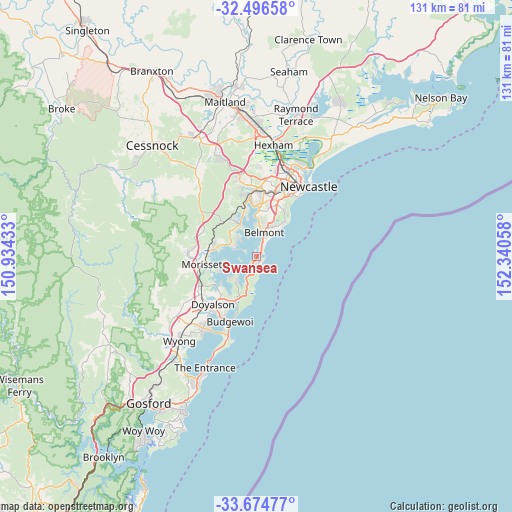
Swansea GPS coordinates[2]
33° 5' 15.54" South, 151° 38' 14.82" East
| Map corner | latitude | longitude |
|---|---|---|
| Upper-left | -32.49658°, | 150.93433° |
| Center: | -33.08765°, | 151.63745° |
| Lower-right: | -33.67477°, | 152.34058° |
| Map W x H: | 131×131 km | = 81.4×81.4mi |
| max Lat: | -10.58257° ⇑43.2% North |
| Swansea: | -33.08765° |
| min Lat: | ⇓56.8% South -43.31423° |
| min Long | Swansea | max Long |
| 113.53327° | 151.63745° | 153.61246° |
| W 79.5%⇐ | ⇒20.5% E |
Elevation
Elevation of Swansea is 4 m = 13 ft, and this is 118 m = 387 ft below average elevation for this country.
| Max E: |
1715 m = 5627 ft | 98.1% |
| Avg. | 122 m = 400 ft | |
| Swansea | 4 m = 13 ft | |
Min E: |
-2 m = -7 ft | 1.9% |
See also: Australia elevation on elevation.city.
Geographical zone
Swansea is located in South temperate zone (between Tropic of Capricorn and the Antarctic Circle). Distance of this Southern Tropic circle is 1073.1 km =666.8 mi to North.| Distance of | km | miles | from Swansea |
|---|---|---|---|
| Equator | 3679 | 2286 | to North |
| Tropic Capricorn | 1073.1 | 666.8 | to North |
| Antarctic Circle | 3722.2 | 2312.9 | to South |
| South Pole | 6328.1 | 3932.1 | to South |


Nearby cities:
15 places around Swansea: (largest is in red/bold)
• Arcadia vale
5.8 km =3.6 mi,  301°
301°
• Belmont
7 km =4.3 mi,  17°
17°
• Belmont South
4.6 km =2.9 mi, 23°
• Blacksmiths
2.4 km =1.5 mi,  43°
43°
• Buttaba
6.7 km =4.2 mi, 304°
• Caves Beach
2.2 km =1.4 mi,  163°
163°
• Coal Point
5.6 km =3.5 mi,  334°
334°
• Fishing Point
5.5 km =3.4 mi,  313°
313°
• Gwandalan
7.4 km =4.6 mi,  223°
223°
• Marks Point
3.6 km =2.2 mi, 18°
• Murrays Beach
3.6 km =2.2 mi,  204°
204°
• Nords Wharf
5.6 km =3.5 mi,  210°
210°
• Pelican
1.8 km =1.1 mi, 23°
• Swansea Heads
1.9 km =1.2 mi,  121°
121°
• Wangi Wangi
4 km =2.5 mi, 295°
Sources, notices
• [Note1] Compared only with cities in Australia existing in our database
• [Src1] Map data: © OpenStreetMap contributors (CC-BY-SA)
• [Src2] Other city data from geonames.org with taken over terms of usage.
• [Src3] Geographical zone / Annual Mean Temperature by Robert A. Rohde @ Wikipedia
