Pelican geodata
Pelican (New South Wales) is a section of populated place; located in Australia in Australia/Sydney (GMT+11) time zone. With population of 850 people, there are 4062 cities with bigger population in this country. Compared to other cities in Australia, 56.9% of cities are located further ↓South; 79.7% of cities are located further ←West and 99.9% of cities have higher elevation than Pelican. Note1


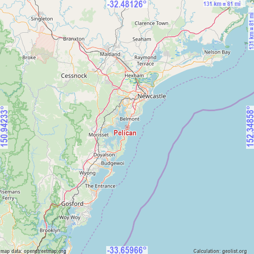
Pelican GPS coordinates[2]
33° 4' 20.748" South, 151° 38' 43.62" East
| Map corner | latitude | longitude |
|---|---|---|
| Upper-left | -32.48126°, | 150.94233° |
| Center: | -33.07243°, | 151.64545° |
| Lower-right: | -33.65966°, | 152.34858° |
| Map W x H: | 131×131 km | = 81.4×81.4mi |
| max Lat: | -10.58257° ⇑43.1% North |
| Pelican: | -33.07243° |
| min Lat: | ⇓56.9% South -43.31423° |
| min Long | Pelican | max Long |
| 113.53327° | 151.64545° | 153.61246° |
| W 79.7%⇐ | ⇒20.3% E |
Elevation
Elevation of Pelican is 1 m = 3 ft, and this is 121 m = 397 ft below average elevation for this country.
| Max E: |
1715 m = 5627 ft | 99.9% |
| Avg. | 122 m = 400 ft | |
| Pelican | 1 m = 3 ft | |
Min E: |
-2 m = -7 ft | 0.1% |
See also: Australia elevation on elevation.city.
Geographical zone
Pelican is located in South temperate zone (between Tropic of Capricorn and the Antarctic Circle). Distance of this Southern Tropic circle is 1071.4 km =665.7 mi to North.| Distance of | km | miles | from Pelican |
|---|---|---|---|
| Equator | 3677.3 | 2285 | to North |
| Tropic Capricorn | 1071.4 | 665.7 | to North |
| Antarctic Circle | 3723.9 | 2313.9 | to South |
| South Pole | 6329.8 | 3933.2 | to South |


Nearby cities:
15 places around Pelican: (largest is in red/bold)
• Arcadia vale
5.9 km =3.7 mi,  283°
283°
• Belmont
5.2 km =3.2 mi,  15°
15°
• Belmont North
6.1 km =3.8 mi, 20°
• Belmont South
2.8 km =1.7 mi, 22°
• Blacksmiths
0.9 km =0.6 mi,  84°
84°
• Carey Bay
6.3 km =3.9 mi,  323°
323°
• Caves Beach
3.8 km =2.4 mi,  182°
182°
• Coal Point
4.6 km =2.9 mi, 316°
• Fishing Point
5.2 km =3.2 mi,  293°
293°
• Marks Point
1.8 km =1.1 mi,  12°
12°
• Murrays Beach
5.5 km =3.4 mi,  204°
204°
• Swansea
1.8 km =1.1 mi, 203°
• Swansea Heads
2.8 km =1.7 mi,  161°
161°
• Valentine
6.4 km =4 mi,  357°
357°
• Wangi Wangi
4.4 km =2.7 mi,  270°
270°
Sources, notices
• [Note1] Compared only with cities in Australia existing in our database
• [Src1] Map data: © OpenStreetMap contributors (CC-BY-SA)
• [Src2] Other city data from geonames.org with taken over terms of usage.
• [Src3] Geographical zone / Annual Mean Temperature by Robert A. Rohde @ Wikipedia
