Rhodes geodata
Rhodes (New South Wales) is a section of populated place; located in Australia in Australia/Sydney (GMT+11) time zone. With population of 11,828 people, there are 428 cities with bigger population in this country. Compared to other cities in Australia, 52.8% of cities are located further ↑North; 69.6% of cities are located further ←West and 70.9% of cities have higher elevation than Rhodes. Note1


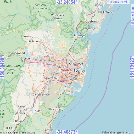
Rhodes GPS coordinates[2]
33° 49' 35.868" South, 151° 5' 17.16" East
| Map corner | latitude | longitude |
|---|---|---|
| Upper-left | -33.24054°, | 150.38498° |
| Center: | -33.82663°, | 151.0881° |
| Lower-right: | -34.40873°, | 151.79123° |
| Map W x H: | 129.9×129.9 km | = 80.7×80.7mi |
| max Lat: | -10.58257° ⇑52.8% North |
| Rhodes: | -33.82663° |
| min Lat: | ⇓47.2% South -43.31423° |
| min Long | Rhodes | max Long |
| 113.53327° | 151.0881° | 153.61246° |
| W 69.6%⇐ | ⇒30.4% E |
Elevation
Elevation of Rhodes is 22 m = 72 ft, and this is 100 m = 328 ft below average elevation for this country.
| Max E: |
1715 m = 5627 ft | 70.9% |
| Avg. | 122 m = 400 ft | |
| Rhodes | 22 m = 72 ft | |
Min E: |
-2 m = -7 ft | 29.1% |
See also: Australia elevation on elevation.city.
Geographical zone
Rhodes is located in South temperate zone (between Tropic of Capricorn and the Antarctic Circle). Distance of this Southern Tropic circle is 1155.2 km =717.8 mi to North.| Distance of | km | miles | from Rhodes |
|---|---|---|---|
| Equator | 3761.2 | 2337.1 | to North |
| Tropic Capricorn | 1155.2 | 717.8 | to North |
| Antarctic Circle | 3640 | 2261.8 | to South |
| South Pole | 6245.9 | 3881 | to South |


Nearby cities:
15 places around Rhodes: (largest is in red/bold)
• Breakfast Point
2.8 km =1.7 mi,  130°
130°
• Concord
2.7 km =1.7 mi,  147°
147°
• Concord West
2.4 km =1.5 mi,  184°
184°
• Denistone
3.2 km =2 mi,  4°
4°
• Denistone West
3.1 km =1.9 mi,  339°
339°
• Liberty Grove
1.6 km =1 mi,  193°
193°
• Meadowbank
1.1 km =0.7 mi, 2°
• Melrose Park
2 km =1.2 mi,  311°
311°
• Mortlake
2.5 km =1.6 mi, 134°
• Newington
3 km =1.9 mi,  252°
252°
• Putney
1.7 km =1.1 mi,  88°
88°
• Ryde
1.9 km =1.2 mi,  62°
62°
• Tennyson Point
2.7 km =1.7 mi,  102°
102°
• Wentworth Point
1.3 km =0.8 mi, 249°
• West Ryde
2.7 km =1.7 mi,  330°
330°
Sources, notices
• [Note1] Compared only with cities in Australia existing in our database
• [Src1] Map data: © OpenStreetMap contributors (CC-BY-SA)
• [Src2] Other city data from geonames.org with taken over terms of usage.
• [Src3] Geographical zone / Annual Mean Temperature by Robert A. Rohde @ Wikipedia
