Newington geodata
Newington (New South Wales) is a section of populated place; located in Australia in Australia/Sydney (GMT+11) time zone. With population of 5,741 people, there are 1276 cities with bigger population in this country. Compared to other cities in Australia, 53.1% of cities are located further ↑North; 68.8% of cities are located further ←West and 73.6% of cities have higher elevation than Newington. Note1


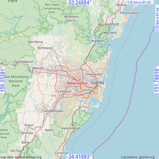
Newington GPS coordinates[2]
33° 50' 5.568" South, 151° 3' 25.308" East
| Map corner | latitude | longitude |
|---|---|---|
| Upper-left | -33.24884°, | 150.35391° |
| Center: | -33.83488°, | 151.05703° |
| Lower-right: | -34.41693°, | 151.76016° |
| Map W x H: | 129.9×129.9 km | = 80.7×80.7mi |
| max Lat: | -10.58257° ⇑53.1% North |
| Newington: | -33.83488° |
| min Lat: | ⇓46.9% South -43.31423° |
| min Long | Newington | max Long |
| 113.53327° | 151.05703° | 153.61246° |
| W 68.8%⇐ | ⇒31.2% E |
Elevation
Elevation of Newington is 20 m = 66 ft, and this is 102 m = 335 ft below average elevation for this country.
| Max E: |
1715 m = 5627 ft | 73.6% |
| Avg. | 122 m = 400 ft | |
| Newington | 20 m = 66 ft | |
Min E: |
-2 m = -7 ft | 26.4% |
See also: Australia elevation on elevation.city.
Geographical zone
Newington is located in South temperate zone (between Tropic of Capricorn and the Antarctic Circle). Distance of this Southern Tropic circle is 1156.2 km =718.4 mi to North.| Distance of | km | miles | from Newington |
|---|---|---|---|
| Equator | 3762.1 | 2337.7 | to North |
| Tropic Capricorn | 1156.2 | 718.4 | to North |
| Antarctic Circle | 3639.1 | 2261.2 | to South |
| South Pole | 6245 | 3880.5 | to South |


Nearby cities:
15 places around Newington: (largest is in red/bold)
• Auburn
2.8 km =1.7 mi,  232°
232°
• Concord West
3.1 km =1.9 mi,  118°
118°
• Ermington
2.2 km =1.4 mi,  354°
354°
• Homebush West
3.2 km =2 mi,  163°
163°
• Liberty Grove
2.6 km =1.6 mi,  105°
105°
• Lidcombe
3.6 km =2.2 mi,  206°
206°
• Meadowbank
3.6 km =2.2 mi,  55°
55°
• Melrose Park
2.6 km =1.6 mi,  32°
32°
• Rhodes
3 km =1.9 mi,  72°
72°
• Rosehill
3.4 km =2.1 mi,  298°
298°
• Rydalmere
2.9 km =1.8 mi,  321°
321°
• Silverwater
0.9 km =0.6 mi,  280°
280°
• Sydney Olympic Park
2 km =1.2 mi,  147°
147°
• Wentworth Point
1.7 km =1.1 mi, 74°
• West Ryde
3.6 km =2.2 mi, 25°
Sources, notices
• [Note1] Compared only with cities in Australia existing in our database
• [Src1] Map data: © OpenStreetMap contributors (CC-BY-SA)
• [Src2] Other city data from geonames.org with taken over terms of usage.
• [Src3] Geographical zone / Annual Mean Temperature by Robert A. Rohde @ Wikipedia
