New Norfolk geodata
New Norfolk (Tasmania) is a populated place; located in Australia in Australia/Hobart (GMT+11) time zone. With population of 5,366 people, there are 1387 cities with bigger population in this country. Compared to other cities in Australia, 98.5% of cities are located further ↑North; 52.8% of cities are located further →East and 53.7% of cities have higher elevation than New Norfolk. Note1


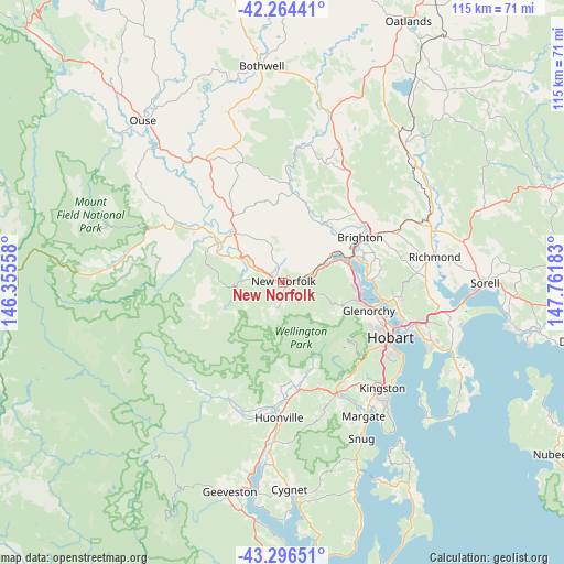
New Norfolk GPS coordinates[2]
42° 46' 57.396" South, 147° 3' 31.32" East
| Map corner | latitude | longitude |
|---|---|---|
| Upper-left | -42.26441°, | 146.35558° |
| Center: | -42.78261°, | 147.0587° |
| Lower-right: | -43.29651°, | 147.76183° |
| Map W x H: | 114.8×114.8 km | = 71.3×71.3mi |
| max Lat: | -10.58257° ⇑98.5% North |
| New Norfolk: | -42.78261° |
| min Lat: | ⇓1.5% South -43.31423° |
| min Long | New Norfolk | max Long |
| 113.53327° | 147.0587° | 153.61246° |
| W 47.2%⇐ | ⇒52.8% E |
Elevation
Elevation of New Norfolk is 40 m = 131 ft, and this is 82 m = 269 ft below average elevation for this country.
| Max E: |
1715 m = 5627 ft | 53.7% |
| Avg. | 122 m = 400 ft | |
| New Norfolk | 40 m = 131 ft | |
Min E: |
-2 m = -7 ft | 46.3% |
See also: Australia elevation on elevation.city.
Geographical zone
New Norfolk is located in South temperate zone (between Tropic of Capricorn and the Antarctic Circle). Distance of this Southern Tropic circle is 2151.1 km =1336.6 mi to North.| Distance of | km | miles | from New Norfolk |
|---|---|---|---|
| Equator | 4757 | 2955.9 | to North |
| Tropic Capricorn | 2151.1 | 1336.6 | to North |
| Antarctic Circle | 2644.2 | 1643 | to South |
| South Pole | 5250.1 | 3262.3 | to South |


Nearby cities:
15 places around New Norfolk: (largest is in red/bold)
• Austins Ferry
15.7 km =9.8 mi,  83°
83°
• Berriedale
16.1 km =10 mi,  103°
103°
• Bridgewater
14.7 km =9.1 mi,  69°
69°
• Chigwell
15.5 km =9.6 mi, 100°
• Claremont
15.6 km =9.7 mi,  90°
90°
• Collinsvale
13 km =8.1 mi,  120°
120°
• Dromedary
10.4 km =6.5 mi,  58°
58°
• Gagebrook
17.7 km =11 mi, 77°
• Granton
14.2 km =8.8 mi, 75°
• Herdsmans Cove
17.2 km =10.7 mi, 78°
• Lachlan
5.7 km =3.5 mi,  187°
187°
• Magra
3.7 km =2.3 mi,  10°
10°
• Montrose
16.2 km =10.1 mi,  108°
108°
• Old Beach
17 km =10.6 mi, 88°
• Rosetta
16.4 km =10.2 mi, 105°
Sources, notices
• [Note1] Compared only with cities in Australia existing in our database
• [Src1] Map data: © OpenStreetMap contributors (CC-BY-SA)
• [Src2] Other city data from geonames.org with taken over terms of usage.
• [Src3] Geographical zone / Annual Mean Temperature by Robert A. Rohde @ Wikipedia
