Rosetta geodata
Rosetta (Tasmania) is a section of populated place; located in Australia in Australia/Hobart (GMT+11) time zone. With population of 2,684 people, there are 2444 cities with bigger population in this country. Compared to other cities in Australia, 98.7% of cities are located further ↑North; 51.6% of cities are located further →East and 63.7% of cities have lower elevation than Rosetta. Note1


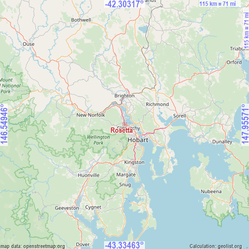
Rosetta GPS coordinates[2]
42° 49' 15.78" South, 147° 15' 9.288" East
| Map corner | latitude | longitude |
|---|---|---|
| Upper-left | -42.30317°, | 146.54946° |
| Center: | -42.82105°, | 147.25258° |
| Lower-right: | -43.33463°, | 147.95571° |
| Map W x H: | 114.7×114.7 km | = 71.3×71.3mi |
| max Lat: | -10.58257° ⇑98.7% North |
| Rosetta: | -42.82105° |
| min Lat: | ⇓1.3% South -43.31423° |
| min Long | Rosetta | max Long |
| 113.53327° | 147.25258° | 153.61246° |
| W 48.4%⇐ | ⇒51.6% E |
Elevation
Elevation of Rosetta is 75 m = 246 ft, and this is 47 m = 154 ft below average elevation for this country.
| Max E: |
1715 m = 5627 ft | 36.3% |
| Avg. | 122 m = 400 ft | |
| Rosetta | 75 m = 246 ft | |
Min E: |
-2 m = -7 ft | 63.7% |
See also: Australia elevation on elevation.city.
Geographical zone
Rosetta is located in South temperate zone (between Tropic of Capricorn and the Antarctic Circle). Distance of this Southern Tropic circle is 2155.3 km =1339.2 mi to North.| Distance of | km | miles | from Rosetta |
|---|---|---|---|
| Equator | 4761.3 | 2958.5 | to North |
| Tropic Capricorn | 2155.3 | 1339.2 | to North |
| Antarctic Circle | 2639.9 | 1640.4 | to South |
| South Pole | 5245.8 | 3259.6 | to South |


Nearby cities:
15 places around Rosetta: (largest is in red/bold)
• Berriedale
0.5 km =0.3 mi,  336°
336°
• Chigwell
1.5 km =0.9 mi,  334°
334°
• Claremont
4.2 km =2.6 mi,  357°
357°
• Collinsvale
5.1 km =3.2 mi,  243°
243°
• Derwent Park
3.8 km =2.4 mi,  114°
114°
• Glenorchy
2.3 km =1.4 mi,  125°
125°
• Goodwood
3.4 km =2.1 mi,  103°
103°
• Lenah Valley
5.9 km =3.7 mi,  161°
161°
• Lutana
5 km =3.1 mi, 107°
• Montrose
1 km =0.6 mi,  205°
205°
• Moonah
4.9 km =3 mi,  124°
124°
• New Town
6.1 km =3.8 mi, 131°
• Old Beach
5 km =3.1 mi,  13°
13°
• Otago
4 km =2.5 mi,  69°
69°
• West Moonah
4 km =2.5 mi,  143°
143°
Sources, notices
• [Note1] Compared only with cities in Australia existing in our database
• [Src1] Map data: © OpenStreetMap contributors (CC-BY-SA)
• [Src2] Other city data from geonames.org with taken over terms of usage.
• [Src3] Geographical zone / Annual Mean Temperature by Robert A. Rohde @ Wikipedia
