Newington geodata
Newington (Victoria) is a section of populated place; located in Australia in Australia/Melbourne (GMT+11) time zone. With population of 1,876 people, there are 2989 cities with bigger population in this country. Compared to other cities in Australia, 83% of cities are located further ↑North; 73.1% of cities are located further →East and 92.7% of cities have lower elevation than Newington. Note1


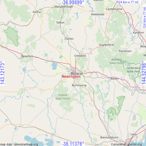
Newington GPS coordinates[2]
37° 33' 30.456" South, 143° 49' 29.46" East
| Map corner | latitude | longitude |
|---|---|---|
| Upper-left | -36.99899°, | 143.12173° |
| Center: | -37.55846°, | 143.82485° |
| Lower-right: | -38.11376°, | 144.52798° |
| Map W x H: | 124×124 km | = 77.1×77.1mi |
| max Lat: | -10.58257° ⇑83% North |
| Newington: | -37.55846° |
| min Lat: | ⇓17% South -43.31423° |
| min Long | Newington | max Long |
| 113.53327° | 143.82485° | 153.61246° |
| W 26.9%⇐ | ⇒73.1% E |
Elevation
Elevation of Newington is 462 m = 1516 ft, and this is 340 m = 1115 ft above average elevation for this country.
| Max E: |
1715 m = 5627 ft | 7.3% |
| Newington | 462 m 1516 ft | |
| Avg. | 122 m = 400 ft | |
Min E: |
-2 m = -7 ft | 92.7% |
See also: Australia elevation on elevation.city.
Geographical zone
Newington is located in South temperate zone (between Tropic of Capricorn and the Antarctic Circle). Distance of this Southern Tropic circle is 1570.2 km =975.7 mi to North.| Distance of | km | miles | from Newington |
|---|---|---|---|
| Equator | 4176.1 | 2594.9 | to North |
| Tropic Capricorn | 1570.2 | 975.7 | to North |
| Antarctic Circle | 3225.1 | 2004 | to South |
| South Pole | 5831 | 3623.2 | to South |


Nearby cities:
15 places around Newington: (largest is in red/bold)
• Alfredton
1.2 km =0.7 mi,  218°
218°
• Ballarat
2.3 km =1.4 mi,  111°
111°
• Ballarat Central
2.3 km =1.4 mi,  99°
99°
• Ballarat East
3.8 km =2.4 mi, 103°
• Ballarat North
4.2 km =2.6 mi,  61°
61°
• Black Hill
3.8 km =2.4 mi,  75°
75°
• Delacombe
3.5 km =2.2 mi,  194°
194°
• Golden Point
4.3 km =2.7 mi,  115°
115°
• Invermay Park
4.3 km =2.7 mi,  43°
43°
• Lake Gardens
1.5 km =0.9 mi,  331°
331°
• Lake Wendouree
2.2 km =1.4 mi, 64°
• Redan
2.3 km =1.4 mi,  148°
148°
• Sebastopol
3.3 km =2.1 mi,  156°
156°
• Soldiers Hill
3.1 km =1.9 mi,  71°
71°
• Wendouree
3.1 km =1.9 mi,  5°
5°
Sources, notices
• [Note1] Compared only with cities in Australia existing in our database
• [Src1] Map data: © OpenStreetMap contributors (CC-BY-SA)
• [Src2] Other city data from geonames.org with taken over terms of usage.
• [Src3] Geographical zone / Annual Mean Temperature by Robert A. Rohde @ Wikipedia
