Wendouree geodata
Wendouree (Victoria) is a section of populated place; located in Australia in Australia/Melbourne (GMT+11) time zone. With population of 10,197 people, there are 572 cities with bigger population in this country. Compared to other cities in Australia, 82.7% of cities are located further ↑North; 73% of cities are located further →East and 92.5% of cities have lower elevation than Wendouree. Note1


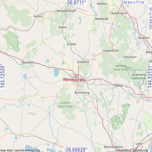
Wendouree GPS coordinates[2]
37° 31' 50.808" South, 143° 49' 42.168" East
| Map corner | latitude | longitude |
|---|---|---|
| Upper-left | -36.9711°, | 143.12526° |
| Center: | -37.53078°, | 143.82838° |
| Lower-right: | -38.08629°, | 144.53151° |
| Map W x H: | 124×124 km | = 77.1×77.1mi |
| max Lat: | -10.58257° ⇑82.7% North |
| Wendouree: | -37.53078° |
| min Lat: | ⇓17.3% South -43.31423° |
| min Long | Wendouree | max Long |
| 113.53327° | 143.82838° | 153.61246° |
| W 27%⇐ | ⇒73% E |
Elevation
Elevation of Wendouree is 455 m = 1493 ft, and this is 333 m = 1093 ft above average elevation for this country.
| Max E: |
1715 m = 5627 ft | 7.5% |
| Wendouree | 455 m 1493 ft | |
| Avg. | 122 m = 400 ft | |
Min E: |
-2 m = -7 ft | 92.5% |
See also: Australia elevation on elevation.city.
Geographical zone
Wendouree is located in South temperate zone (between Tropic of Capricorn and the Antarctic Circle). Distance of this Southern Tropic circle is 1567.1 km =973.8 mi to North.| Distance of | km | miles | from Wendouree |
|---|---|---|---|
| Equator | 4173 | 2593 | to North |
| Tropic Capricorn | 1567.1 | 973.8 | to North |
| Antarctic Circle | 3228.1 | 2005.8 | to South |
| South Pole | 5834 | 3625.1 | to South |


Nearby cities:
15 places around Wendouree: (largest is in red/bold)
• Alfredton
4.1 km =2.5 mi,  194°
194°
• Ballarat
4.4 km =2.7 mi,  154°
154°
• Ballarat Central
4 km =2.5 mi, 150°
• Ballarat East
5.2 km =3.2 mi,  139°
139°
• Ballarat North
3.5 km =2.2 mi,  108°
108°
• Black Hill
4 km =2.5 mi,  122°
122°
• Invermay
5 km =3.1 mi,  71°
71°
• Invermay Park
2.6 km =1.6 mi,  89°
89°
• Lake Gardens
2 km =1.2 mi,  211°
211°
• Lake Wendouree
2.7 km =1.7 mi, 141°
• Lucas
4.9 km =3 mi,  250°
250°
• Mitchell Park
5 km =3.1 mi,  301°
301°
• Newington
3.1 km =1.9 mi, 185°
• Redan
5.2 km =3.2 mi,  169°
169°
• Soldiers Hill
3.4 km =2.1 mi,  128°
128°
Sources, notices
• [Note1] Compared only with cities in Australia existing in our database
• [Src1] Map data: © OpenStreetMap contributors (CC-BY-SA)
• [Src2] Other city data from geonames.org with taken over terms of usage.
• [Src3] Geographical zone / Annual Mean Temperature by Robert A. Rohde @ Wikipedia
