Mordialloc geodata
Mordialloc (Victoria) is a section of populated place; located in Australia in Australia/Melbourne (GMT+11) time zone. With population of 8,027 people, there are 833 cities with bigger population in this country. Compared to other cities in Australia, 91.8% of cities are located further ↑North; 64.8% of cities are located further →East and 83.5% of cities have higher elevation than Mordialloc. Note1


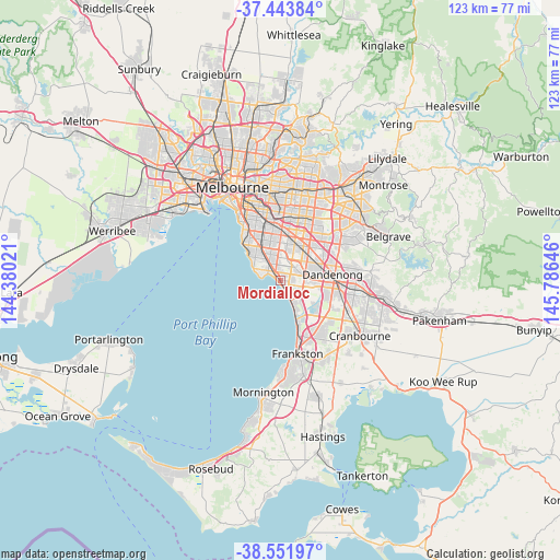
Mordialloc GPS coordinates[2]
38° 0' 0" South, 145° 4' 59.988" East
| Map corner | latitude | longitude |
|---|---|---|
| Upper-left | -37.44384°, | 144.38021° |
| Center: | -38°, | 145.08333° |
| Lower-right: | -38.55197°, | 145.78646° |
| Map W x H: | 123.2×123.2 km | = 76.6×76.6mi |
| max Lat: | -10.58257° ⇑91.8% North |
| Mordialloc: | -38° |
| min Lat: | ⇓8.2% South -43.31423° |
| min Long | Mordialloc | max Long |
| 113.53327° | 145.08333° | 153.61246° |
| W 35.2%⇐ | ⇒64.8% E |
Elevation
Elevation of Mordialloc is 13 m = 43 ft, and this is 109 m = 358 ft below average elevation for this country.
| Max E: |
1715 m = 5627 ft | 83.5% |
| Avg. | 122 m = 400 ft | |
| Mordialloc | 13 m = 43 ft | |
Min E: |
-2 m = -7 ft | 16.5% |
See also: Australia elevation on elevation.city.
Geographical zone
Mordialloc is located in South temperate zone (between Tropic of Capricorn and the Antarctic Circle). Distance of this Southern Tropic circle is 1619.3 km =1006.2 mi to North.| Distance of | km | miles | from Mordialloc |
|---|---|---|---|
| Equator | 4225.2 | 2625.4 | to North |
| Tropic Capricorn | 1619.3 | 1006.2 | to North |
| Antarctic Circle | 3176 | 1973.5 | to South |
| South Pole | 5781.9 | 3592.7 | to South |


Nearby cities:
15 places around Mordialloc: (largest is in red/bold)
• Aspendale
3.7 km =2.3 mi,  152°
152°
• Aspendale Gardens
4 km =2.5 mi,  129°
129°
• Beaumaris
4.7 km =2.9 mi,  290°
290°
• Black Rock
6.6 km =4.1 mi,  296°
296°
• Chelsea
6.3 km =3.9 mi, 152°
• Chelsea Heights
5.7 km =3.5 mi, 130°
• Cheltenham
4.6 km =2.9 mi,  317°
317°
• Dingley Village
4.9 km =3 mi,  66°
66°
• Edithvale
4.7 km =2.9 mi, 150°
• Heatherton
4 km =2.5 mi,  21°
21°
• Highett
6.3 km =3.9 mi,  332°
332°
• Kooyong
6.3 km =3.9 mi, 332°
• Mentone
2.4 km =1.5 mi, 321°
• Parkdale
0.9 km =0.6 mi,  348°
348°
• Waterways
4.4 km =2.7 mi,  111°
111°
Sources, notices
• [Note1] Compared only with cities in Australia existing in our database
• [Src1] Map data: © OpenStreetMap contributors (CC-BY-SA)
• [Src2] Other city data from geonames.org with taken over terms of usage.
• [Src3] Geographical zone / Annual Mean Temperature by Robert A. Rohde @ Wikipedia
