Cheltenham geodata
Cheltenham (Victoria) is a section of populated place; located in Australia in Australia/Melbourne (GMT+11) time zone. With population of 21,837 people, there are 141 cities with bigger population in this country. Compared to other cities in Australia, 91.5% of cities are located further ↑North; 65.3% of cities are located further →East and 53.1% of cities have higher elevation than Cheltenham. Note1


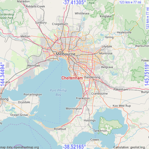
Cheltenham GPS coordinates[2]
37° 58' 9.984" South, 145° 2' 53.016" East
| Map corner | latitude | longitude |
|---|---|---|
| Upper-left | -37.41305°, | 144.34494° |
| Center: | -37.96944°, | 145.04806° |
| Lower-right: | -38.52165°, | 145.75119° |
| Map W x H: | 123.3×123.3 km | = 76.6×76.6mi |
| max Lat: | -10.58257° ⇑91.5% North |
| Cheltenham: | -37.96944° |
| min Lat: | ⇓8.5% South -43.31423° |
| min Long | Cheltenham | max Long |
| 113.53327° | 145.04806° | 153.61246° |
| W 34.7%⇐ | ⇒65.3% E |
Elevation
Elevation of Cheltenham is 41 m = 135 ft, and this is 81 m = 266 ft below average elevation for this country.
| Max E: |
1715 m = 5627 ft | 53.1% |
| Avg. | 122 m = 400 ft | |
| Cheltenham | 41 m = 135 ft | |
Min E: |
-2 m = -7 ft | 46.9% |
See also: Australia elevation on elevation.city.
Geographical zone
Cheltenham is located in South temperate zone (between Tropic of Capricorn and the Antarctic Circle). Distance of this Southern Tropic circle is 1615.9 km =1004.1 mi to North.| Distance of | km | miles | from Cheltenham |
|---|---|---|---|
| Equator | 4221.8 | 2623.3 | to North |
| Tropic Capricorn | 1615.9 | 1004.1 | to North |
| Antarctic Circle | 3179.4 | 1975.6 | to South |
| South Pole | 5785.3 | 3594.8 | to South |


Nearby cities:
15 places around Cheltenham: (largest is in red/bold)
• Beaumaris
2.2 km =1.4 mi,  215°
215°
• Bentleigh
5.8 km =3.6 mi,  349°
349°
• Bentleigh East
5.6 km =3.5 mi,  4°
4°
• Black Rock
2.8 km =1.7 mi,  260°
260°
• Clarinda
5.7 km =3.5 mi,  56°
56°
• Hampton
4.7 km =2.9 mi,  297°
297°
• Hampton East
4 km =2.5 mi,  334°
334°
• Heatherton
4.6 km =2.9 mi,  86°
86°
• Highett
2.2 km =1.4 mi, 4°
• Kooyong
2.2 km =1.4 mi, 4°
• Mentone
2.2 km =1.4 mi,  133°
133°
• Moorabbin
3.2 km =2 mi,  15°
15°
• Mordialloc
4.6 km =2.9 mi,  137°
137°
• Parkdale
3.8 km =2.4 mi, 130°
• Sandringham
3.8 km =2.4 mi, 300°
Sources, notices
• [Note1] Compared only with cities in Australia existing in our database
• [Src1] Map data: © OpenStreetMap contributors (CC-BY-SA)
• [Src2] Other city data from geonames.org with taken over terms of usage.
• [Src3] Geographical zone / Annual Mean Temperature by Robert A. Rohde @ Wikipedia
