Moonah geodata
Moonah (Tasmania) is a section of populated place; located in Australia in Australia/Hobart (GMT+11) time zone. With population of 5,311 people, there are 1399 cities with bigger population in this country. Compared to other cities in Australia, 98.9% of cities are located further ↑North; 51.2% of cities are located further →East and 60% of cities have higher elevation than Moonah. Note1


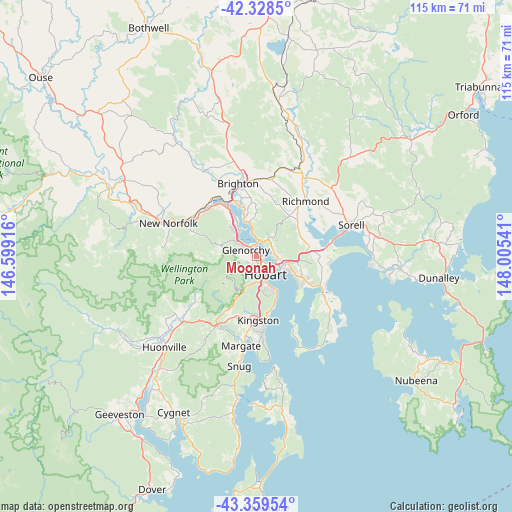
Moonah GPS coordinates[2]
42° 50' 46.212" South, 147° 18' 8.208" East
| Map corner | latitude | longitude |
|---|---|---|
| Upper-left | -42.3285°, | 146.59916° |
| Center: | -42.84617°, | 147.30228° |
| Lower-right: | -43.35954°, | 148.00541° |
| Map W x H: | 114.6×114.6 km | = 71.2×71.2mi |
| max Lat: | -10.58257° ⇑98.9% North |
| Moonah: | -42.84617° |
| min Lat: | ⇓1.1% South -43.31423° |
| min Long | Moonah | max Long |
| 113.53327° | 147.30228° | 153.61246° |
| W 48.8%⇐ | ⇒51.2% E |
Elevation
Elevation of Moonah is 32 m = 105 ft, and this is 90 m = 295 ft below average elevation for this country.
| Max E: |
1715 m = 5627 ft | 60% |
| Avg. | 122 m = 400 ft | |
| Moonah | 32 m = 105 ft | |
Min E: |
-2 m = -7 ft | 40% |
See also: Australia elevation on elevation.city.
Geographical zone
Moonah is located in South temperate zone (between Tropic of Capricorn and the Antarctic Circle). Distance of this Southern Tropic circle is 2158.1 km =1341 mi to North.| Distance of | km | miles | from Moonah |
|---|---|---|---|
| Equator | 4764 | 2960.2 | to North |
| Tropic Capricorn | 2158.1 | 1341 | to North |
| Antarctic Circle | 2637.1 | 1638.6 | to South |
| South Pole | 5243 | 3257.8 | to South |


Nearby cities:
15 places around Moonah: (largest is in red/bold)
• Derwent Park
1.4 km =0.9 mi,  334°
334°
• Geilston Bay
4 km =2.5 mi,  62°
62°
• Glebe
3.8 km =2.4 mi,  146°
146°
• Glenorchy
2.6 km =1.6 mi,  303°
303°
• Goodwood
2.1 km =1.3 mi,  339°
339°
• Hobart
4.3 km =2.7 mi, 149°
• Hobart city centre
4.5 km =2.8 mi, 154°
• Lenah Valley
3.6 km =2.2 mi,  218°
218°
• Lutana
1.5 km =0.9 mi,  30°
30°
• Mount Stuart
2.8 km =1.7 mi,  181°
181°
• New Town
1.4 km =0.9 mi,  157°
157°
• North Hobart
3.3 km =2.1 mi, 160°
• Otago
4.2 km =2.6 mi,  355°
355°
• West Hobart
3.4 km =2.1 mi,  173°
173°
• West Moonah
1.7 km =1.1 mi,  255°
255°
Sources, notices
• [Note1] Compared only with cities in Australia existing in our database
• [Src1] Map data: © OpenStreetMap contributors (CC-BY-SA)
• [Src2] Other city data from geonames.org with taken over terms of usage.
• [Src3] Geographical zone / Annual Mean Temperature by Robert A. Rohde @ Wikipedia
