Glebe geodata
Glebe (Tasmania) is a section of populated place; located in Australia in Australia/Hobart (GMT+11) time zone. With population of 580 people, there are 4622 cities with bigger population in this country. Compared to other cities in Australia, 99.2% of cities are located further ↑North; 50.9% of cities are located further →East and 51.1% of cities have lower elevation than Glebe. Note1


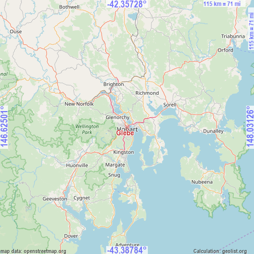
Glebe GPS coordinates[2]
42° 52' 28.956" South, 147° 19' 41.268" East
| Map corner | latitude | longitude |
|---|---|---|
| Upper-left | -42.35728°, | 146.62501° |
| Center: | -42.87471°, | 147.32813° |
| Lower-right: | -43.38784°, | 148.03126° |
| Map W x H: | 114.6×114.6 km | = 71.2×71.2mi |
| max Lat: | -10.58257° ⇑99.2% North |
| Glebe: | -42.87471° |
| min Lat: | ⇓0.8% South -43.31423° |
| min Long | Glebe | max Long |
| 113.53327° | 147.32813° | 153.61246° |
| W 49.1%⇐ | ⇒50.9% E |
Elevation
Elevation of Glebe is 47 m = 154 ft, and this is 75 m = 246 ft below average elevation for this country.
| Max E: |
1715 m = 5627 ft | 48.9% |
| Avg. | 122 m = 400 ft | |
| Glebe | 47 m = 154 ft | |
Min E: |
-2 m = -7 ft | 51.1% |
See also: Australia elevation on elevation.city.
Geographical zone
Glebe is located in South temperate zone (between Tropic of Capricorn and the Antarctic Circle). Distance of this Southern Tropic circle is 2161.3 km =1343 mi to North.| Distance of | km | miles | from Glebe |
|---|---|---|---|
| Equator | 4767.2 | 2962.2 | to North |
| Tropic Capricorn | 2161.3 | 1343 | to North |
| Antarctic Circle | 2634 | 1636.7 | to South |
| South Pole | 5239.8 | 3255.9 | to South |


Nearby cities:
15 places around Glebe: (largest is in red/bold)
• Battery Point
1.7 km =1.1 mi,  166°
166°
• Bellerive
3.4 km =2.1 mi,  91°
91°
• Dynnyrne
3.6 km =2.2 mi,  196°
196°
• Hobart
0.5 km =0.3 mi, 168°
• Hobart city centre
0.9 km =0.6 mi,  191°
191°
• Lindisfarne
4 km =2.5 mi,  43°
43°
• Montagu Bay
2.6 km =1.6 mi,  65°
65°
• Moonah
3.8 km =2.4 mi,  326°
326°
• Mount Stuart
2.2 km =1.4 mi,  279°
279°
• New Town
2.5 km =1.6 mi,  320°
320°
• North Hobart
1 km =0.6 mi,  274°
274°
• Rosny
2.4 km =1.5 mi,  79°
79°
• Sandy Bay
2.2 km =1.4 mi, 187°
• South Hobart
2.7 km =1.7 mi,  214°
214°
• West Hobart
1.7 km =1.1 mi,  263°
263°
Sources, notices
• [Note1] Compared only with cities in Australia existing in our database
• [Src1] Map data: © OpenStreetMap contributors (CC-BY-SA)
• [Src2] Other city data from geonames.org with taken over terms of usage.
• [Src3] Geographical zone / Annual Mean Temperature by Robert A. Rohde @ Wikipedia
