Matcham geodata
Matcham (New South Wales) is a section of populated place; located in Australia in Australia/Sydney (GMT+11) time zone. With population of 947 people, there are 3902 cities with bigger population in this country. Compared to other cities in Australia, 54.3% of cities are located further ↓South; 76.9% of cities are located further ←West and 74.7% of cities have higher elevation than Matcham. Note1


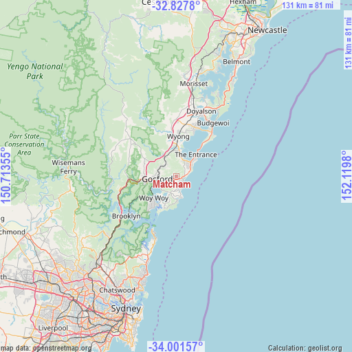
Matcham GPS coordinates[2]
33° 25' 0.012" South, 151° 25' 0.012" East
| Map corner | latitude | longitude |
|---|---|---|
| Upper-left | -32.8278°, | 150.71355° |
| Center: | -33.41667°, | 151.41667° |
| Lower-right: | -34.00157°, | 152.1198° |
| Map W x H: | 130.5×130.5 km | = 81.1×81.1mi |
| max Lat: | -10.58257° ⇑45.7% North |
| Matcham: | -33.41667° |
| min Lat: | ⇓54.3% South -43.31423° |
| min Long | Matcham | max Long |
| 113.53327° | 151.41667° | 153.61246° |
| W 76.9%⇐ | ⇒23.1% E |
Elevation
Elevation of Matcham is 19 m = 62 ft, and this is 103 m = 338 ft below average elevation for this country.
| Max E: |
1715 m = 5627 ft | 74.7% |
| Avg. | 122 m = 400 ft | |
| Matcham | 19 m = 62 ft | |
Min E: |
-2 m = -7 ft | 25.3% |
See also: Australia elevation on elevation.city.
Geographical zone
Matcham is located in South temperate zone (between Tropic of Capricorn and the Antarctic Circle). Distance of this Southern Tropic circle is 1109.7 km =689.5 mi to North.| Distance of | km | miles | from Matcham |
|---|---|---|---|
| Equator | 3715.6 | 2308.8 | to North |
| Tropic Capricorn | 1109.7 | 689.5 | to North |
| Antarctic Circle | 3685.6 | 2290.1 | to South |
| South Pole | 6291.5 | 3909.4 | to South |


Nearby cities:
15 places around Matcham: (largest is in red/bold)
• Avoca Beach
5.9 km =3.7 mi,  164°
164°
• Bateau Bay
5.9 km =3.7 mi,  51°
51°
• East Gosford
6.4 km =4 mi,  247°
247°
• Erina
3 km =1.9 mi,  235°
235°
• Forresters Beach
5.6 km =3.5 mi,  78°
78°
• Glenning Valley
7.1 km =4.4 mi,  7°
7°
• Gosford
6.8 km =4.2 mi,  262°
262°
• Holgate
1.9 km =1.2 mi,  0°
0°
• Lisarow
5.9 km =3.7 mi,  308°
308°
• North Avoca
4.7 km =2.9 mi, 158°
• North Gosford
6 km =3.7 mi,  272°
272°
• Terrigal
4.5 km =2.8 mi,  141°
141°
• Tumbi Vmbi
6.4 km =4 mi,  29°
29°
• Wamberal
2.7 km =1.7 mi,  87°
87°
• Wyoming
5.2 km =3.2 mi,  285°
285°
Sources, notices
• [Note1] Compared only with cities in Australia existing in our database
• [Src1] Map data: © OpenStreetMap contributors (CC-BY-SA)
• [Src2] Other city data from geonames.org with taken over terms of usage.
• [Src3] Geographical zone / Annual Mean Temperature by Robert A. Rohde @ Wikipedia
