Lisarow geodata
Lisarow (New South Wales) is a section of populated place; located in Australia in Australia/Sydney (GMT+11) time zone. With population of 5,036 people, there are 1467 cities with bigger population in this country. Compared to other cities in Australia, 54.7% of cities are located further ↓South; 76.6% of cities are located further ←West and 65.9% of cities have higher elevation than Lisarow. Note1


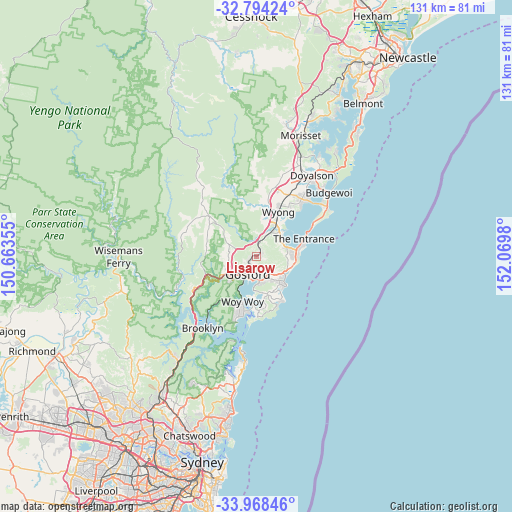
Lisarow GPS coordinates[2]
33° 22' 59.988" South, 151° 22' 0.012" East
| Map corner | latitude | longitude |
|---|---|---|
| Upper-left | -32.79424°, | 150.66355° |
| Center: | -33.38333°, | 151.36667° |
| Lower-right: | -33.96846°, | 152.0698° |
| Map W x H: | 130.6×130.6 km | = 81.2×81.2mi |
| max Lat: | -10.58257° ⇑45.3% North |
| Lisarow: | -33.38333° |
| min Lat: | ⇓54.7% South -43.31423° |
| min Long | Lisarow | max Long |
| 113.53327° | 151.36667° | 153.61246° |
| W 76.6%⇐ | ⇒23.4% E |
Elevation
Elevation of Lisarow is 26 m = 85 ft, and this is 96 m = 315 ft below average elevation for this country.
| Max E: |
1715 m = 5627 ft | 65.9% |
| Avg. | 122 m = 400 ft | |
| Lisarow | 26 m = 85 ft | |
Min E: |
-2 m = -7 ft | 34.1% |
See also: Australia elevation on elevation.city.
Geographical zone
Lisarow is located in South temperate zone (between Tropic of Capricorn and the Antarctic Circle). Distance of this Southern Tropic circle is 1106 km =687.2 mi to North.| Distance of | km | miles | from Lisarow |
|---|---|---|---|
| Equator | 3711.9 | 2306.5 | to North |
| Tropic Capricorn | 1106 | 687.2 | to North |
| Antarctic Circle | 3689.3 | 2292.4 | to South |
| South Pole | 6295.2 | 3911.7 | to South |


Nearby cities:
15 places around Lisarow: (largest is in red/bold)
• Berkeley Vale
7.2 km =4.5 mi,  59°
59°
• East Gosford
6.3 km =3.9 mi,  191°
191°
• Erina
5.8 km =3.6 mi,  158°
158°
• Fountaindale
5.1 km =3.2 mi,  38°
38°
• Glenning Valley
6.4 km =4 mi, 59°
• Gosford
5 km =3.1 mi,  204°
204°
• Holgate
5 km =3.1 mi,  111°
111°
• Matcham
5.9 km =3.7 mi,  128°
128°
• Narara
3.2 km =2 mi,  244°
244°
• Niagara Park
1.8 km =1.1 mi,  294°
294°
• North Gosford
3.7 km =2.3 mi, 202°
• Point Clare
7.6 km =4.7 mi,  208°
208°
• Point Frederick
6.7 km =4.2 mi, 198°
• West Gosford
6.6 km =4.1 mi,  224°
224°
• Wyoming
2.3 km =1.4 mi, 189°
Sources, notices
• [Note1] Compared only with cities in Australia existing in our database
• [Src1] Map data: © OpenStreetMap contributors (CC-BY-SA)
• [Src2] Other city data from geonames.org with taken over terms of usage.
• [Src3] Geographical zone / Annual Mean Temperature by Robert A. Rohde @ Wikipedia
