Luddenham geodata
Luddenham (New South Wales) is a section of populated place; located in Australia in Australia/Sydney (GMT+11) time zone. With population of 1,776 people, there are 3070 cities with bigger population in this country. Compared to other cities in Australia, 54.9% of cities are located further ↑North; 60.6% of cities are located further ←West and 69.7% of cities have lower elevation than Luddenham. Note1


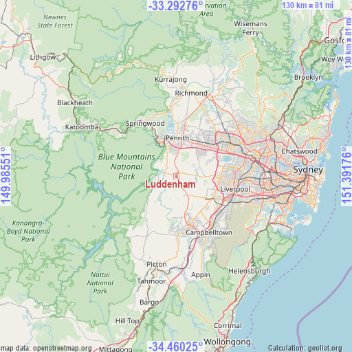
Luddenham GPS coordinates[2]
33° 52' 42.6" South, 150° 41' 19.068" East
| Map corner | latitude | longitude |
|---|---|---|
| Upper-left | -33.29276°, | 149.98551° |
| Center: | -33.8785°, | 150.68863° |
| Lower-right: | -34.46025°, | 151.39176° |
| Map W x H: | 129.8×129.8 km | = 80.7×80.7mi |
| max Lat: | -10.58257° ⇑54.9% North |
| Luddenham: | -33.8785° |
| min Lat: | ⇓45.1% South -43.31423° |
| min Long | Luddenham | max Long |
| 113.53327° | 150.68863° | 153.61246° |
| W 60.6%⇐ | ⇒39.4% E |
Elevation
Elevation of Luddenham is 101 m = 331 ft, and this is 21 m = 69 ft below average elevation for this country.
| Max E: |
1715 m = 5627 ft | 30.3% |
| Avg. | 122 m = 400 ft | |
| Luddenham | 101 m = 331 ft | |
Min E: |
-2 m = -7 ft | 69.7% |
See also: Australia elevation on elevation.city.
Geographical zone
Luddenham is located in South temperate zone (between Tropic of Capricorn and the Antarctic Circle). Distance of this Southern Tropic circle is 1161 km =721.4 mi to North.| Distance of | km | miles | from Luddenham |
|---|---|---|---|
| Equator | 3766.9 | 2340.6 | to North |
| Tropic Capricorn | 1161 | 721.4 | to North |
| Antarctic Circle | 3634.2 | 2258.2 | to South |
| South Pole | 6240.1 | 3877.4 | to South |


Nearby cities:
15 places around Luddenham: (largest is in red/bold)
• Austral
12.3 km =7.6 mi,  116°
116°
• Bringelly
7.4 km =4.6 mi,  145°
145°
• Caddens
12.6 km =7.8 mi,  22°
22°
• Erskine Park
12.4 km =7.7 mi,  54°
54°
• Glenmore Park
9.9 km =6.2 mi,  349°
349°
• Jamisontown
12.3 km =7.6 mi, 354°
• Kemps Creek
9.1 km =5.7 mi,  91°
91°
• Mount Vernon
11.4 km =7.1 mi,  79°
79°
• Mulgoa
5.8 km =3.6 mi,  321°
321°
• Orchard Hills
10.9 km =6.8 mi,  10°
10°
• Regentville
11.7 km =7.3 mi, 349°
• Silverdale
8.4 km =5.2 mi,  240°
240°
• South Penrith
11.7 km =7.3 mi,  2°
2°
• Wallacia
4.7 km =2.9 mi,  287°
287°
• Warragamba
7.9 km =4.9 mi,  259°
259°
Sources, notices
• [Note1] Compared only with cities in Australia existing in our database
• [Src1] Map data: © OpenStreetMap contributors (CC-BY-SA)
• [Src2] Other city data from geonames.org with taken over terms of usage.
• [Src3] Geographical zone / Annual Mean Temperature by Robert A. Rohde @ Wikipedia
