Mulgoa geodata
Mulgoa (New South Wales) is a section of populated place; located in Australia in Australia/Sydney (GMT+11) time zone. With population of 1,848 people, there are 3003 cities with bigger population in this country. Compared to other cities in Australia, 53.2% of cities are located further ↑North; 60.2% of cities are located further ←West and 63.4% of cities have lower elevation than Mulgoa. Note1


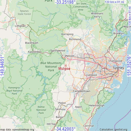
Mulgoa GPS coordinates[2]
33° 50' 16.8" South, 150° 38' 58.668" East
| Map corner | latitude | longitude |
|---|---|---|
| Upper-left | -33.25198°, | 149.94651° |
| Center: | -33.838°, | 150.64963° |
| Lower-right: | -34.42003°, | 151.35276° |
| Map W x H: | 129.9×129.9 km | = 80.7×80.7mi |
| max Lat: | -10.58257° ⇑53.2% North |
| Mulgoa: | -33.838° |
| min Lat: | ⇓46.8% South -43.31423° |
| min Long | Mulgoa | max Long |
| 113.53327° | 150.64963° | 153.61246° |
| W 60.2%⇐ | ⇒39.8% E |
Elevation
Elevation of Mulgoa is 74 m = 243 ft, and this is 48 m = 157 ft below average elevation for this country.
| Max E: |
1715 m = 5627 ft | 36.6% |
| Avg. | 122 m = 400 ft | |
| Mulgoa | 74 m = 243 ft | |
Min E: |
-2 m = -7 ft | 63.4% |
See also: Australia elevation on elevation.city.
Geographical zone
Mulgoa is located in South temperate zone (between Tropic of Capricorn and the Antarctic Circle). Distance of this Southern Tropic circle is 1156.5 km =718.6 mi to North.| Distance of | km | miles | from Mulgoa |
|---|---|---|---|
| Equator | 3762.4 | 2337.8 | to North |
| Tropic Capricorn | 1156.5 | 718.6 | to North |
| Antarctic Circle | 3638.7 | 2261 | to South |
| South Pole | 6244.6 | 3880.2 | to South |


Nearby cities:
15 places around Mulgoa: (largest is in red/bold)
• Emu Plains
9.9 km =6.2 mi,  9°
9°
• Glenbrook
8.5 km =5.3 mi,  338°
338°
• Glenmore Park
5.6 km =3.5 mi,  19°
19°
• Jamisontown
8.2 km =5.1 mi, 17°
• Kingswood Park
9.9 km =6.2 mi,  36°
36°
• Lapstone
7.2 km =4.5 mi,  349°
349°
• Leonay
8.1 km =5 mi,  358°
358°
• Luddenham
5.8 km =3.6 mi,  141°
141°
• Orchard Hills
8.4 km =5.2 mi, 42°
• Penrith
10.8 km =6.7 mi,  25°
25°
• Regentville
7.1 km =4.4 mi, 11°
• Silverdale
9.3 km =5.8 mi,  203°
203°
• South Penrith
8.3 km =5.2 mi, 30°
• Wallacia
3.2 km =2 mi, 195°
• Warragamba
7.3 km =4.5 mi,  214°
214°
Sources, notices
• [Note1] Compared only with cities in Australia existing in our database
• [Src1] Map data: © OpenStreetMap contributors (CC-BY-SA)
• [Src2] Other city data from geonames.org with taken over terms of usage.
• [Src3] Geographical zone / Annual Mean Temperature by Robert A. Rohde @ Wikipedia
