Lovely Banks geodata
Lovely Banks (Victoria) is a section of populated place; located in Australia in Australia/Melbourne (GMT+11) time zone. With population of 2,271 people, there are 2714 cities with bigger population in this country. Compared to other cities in Australia, 92.4% of cities are located further ↑North; 71.1% of cities are located further →East and 55.2% of cities have higher elevation than Lovely Banks. Note1


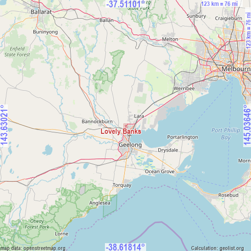
Lovely Banks GPS coordinates[2]
38° 4' 0.012" South, 144° 19' 59.988" East
| Map corner | latitude | longitude |
|---|---|---|
| Upper-left | -37.51101°, | 143.63021° |
| Center: | -38.06667°, | 144.33333° |
| Lower-right: | -38.61814°, | 145.03646° |
| Map W x H: | 123.1×123.1 km | = 76.5×76.5mi |
| max Lat: | -10.58257° ⇑92.4% North |
| Lovely Banks: | -38.06667° |
| min Lat: | ⇓7.6% South -43.31423° |
| min Long | Lovely Banks | max Long |
| 113.53327° | 144.33333° | 153.61246° |
| W 28.9%⇐ | ⇒71.1% E |
Elevation
Elevation of Lovely Banks is 38 m = 125 ft, and this is 84 m = 276 ft below average elevation for this country.
| Max E: |
1715 m = 5627 ft | 55.2% |
| Avg. | 122 m = 400 ft | |
| Lovely Banks | 38 m = 125 ft | |
Min E: |
-2 m = -7 ft | 44.8% |
See also: Australia elevation on elevation.city.
Geographical zone
Lovely Banks is located in South temperate zone (between Tropic of Capricorn and the Antarctic Circle). Distance of this Southern Tropic circle is 1626.7 km =1010.8 mi to North.| Distance of | km | miles | from Lovely Banks |
|---|---|---|---|
| Equator | 4232.6 | 2630 | to North |
| Tropic Capricorn | 1626.7 | 1010.8 | to North |
| Antarctic Circle | 3168.6 | 1968.9 | to South |
| South Pole | 5774.4 | 3588 | to South |


Nearby cities:
15 places around Lovely Banks: (largest is in red/bold)
• Batesford
5.4 km =3.4 mi,  243°
243°
• Bell Park
4.6 km =2.9 mi,  174°
174°
• Bell Post Hill
3.4 km =2.1 mi,  200°
200°
• Corio
4.8 km =3 mi,  112°
112°
• Drumcondra
7.3 km =4.5 mi, 165°
• Geelong
9.3 km =5.8 mi, 165°
• Geelong West
8.1 km =5 mi, 170°
• Geelong city centre
9.6 km =6 mi,  164°
164°
• Hamlyn Heights
6.1 km =3.8 mi,  184°
184°
• Herne Hill
7.6 km =4.7 mi,  186°
186°
• Lara
8 km =5 mi,  53°
53°
• Manifold Heights
7.9 km =4.9 mi, 179°
• Norlane
4.3 km =2.7 mi,  154°
154°
• North Geelong
5 km =3.1 mi, 161°
• Rippleside
6.8 km =4.2 mi, 163°
Sources, notices
• [Note1] Compared only with cities in Australia existing in our database
• [Src1] Map data: © OpenStreetMap contributors (CC-BY-SA)
• [Src2] Other city data from geonames.org with taken over terms of usage.
• [Src3] Geographical zone / Annual Mean Temperature by Robert A. Rohde @ Wikipedia
