Corio geodata
Corio (Victoria) is a section of populated place; located in Australia in Australia/Melbourne (GMT+11) time zone. With population of 15,215 people, there are 267 cities with bigger population in this country. Compared to other cities in Australia, 92.6% of cities are located further ↑North; 70.6% of cities are located further →East and 90.1% of cities have higher elevation than Corio. Note1


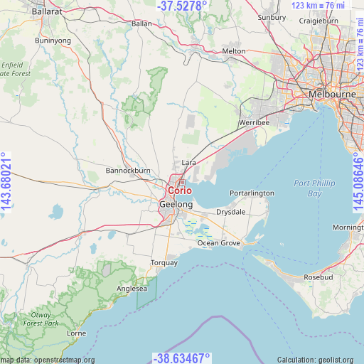
Corio GPS coordinates[2]
38° 4' 59.988" South, 144° 22' 59.988" East
| Map corner | latitude | longitude |
|---|---|---|
| Upper-left | -37.5278°, | 143.68021° |
| Center: | -38.08333°, | 144.38333° |
| Lower-right: | -38.63467°, | 145.08646° |
| Map W x H: | 123.1×123.1 km | = 76.5×76.5mi |
| max Lat: | -10.58257° ⇑92.6% North |
| Corio: | -38.08333° |
| min Lat: | ⇓7.4% South -43.31423° |
| min Long | Corio | max Long |
| 113.53327° | 144.38333° | 153.61246° |
| W 29.4%⇐ | ⇒70.6% E |
Elevation
Elevation of Corio is 9 m = 30 ft, and this is 113 m = 371 ft below average elevation for this country.
| Max E: |
1715 m = 5627 ft | 90.1% |
| Avg. | 122 m = 400 ft | |
| Corio | 9 m = 30 ft | |
Min E: |
-2 m = -7 ft | 9.9% |
See also: Australia elevation on elevation.city.
Geographical zone
Corio is located in South temperate zone (between Tropic of Capricorn and the Antarctic Circle). Distance of this Southern Tropic circle is 1628.6 km =1012 mi to North.| Distance of | km | miles | from Corio |
|---|---|---|---|
| Equator | 4234.5 | 2631.2 | to North |
| Tropic Capricorn | 1628.6 | 1012 | to North |
| Antarctic Circle | 3166.7 | 1967.7 | to South |
| South Pole | 5772.6 | 3586.9 | to South |


Nearby cities:
15 places around Corio: (largest is in red/bold)
• Bell Park
4.8 km =3 mi,  235°
235°
• Bell Post Hill
5.7 km =3.5 mi,  256°
256°
• Drumcondra
5.8 km =3.6 mi,  206°
206°
• East Geelong
8.1 km =5 mi,  187°
187°
• Geelong
7.4 km =4.6 mi,  195°
195°
• Geelong West
6.9 km =4.3 mi, 206°
• Geelong city centre
7.6 km =4.7 mi, 194°
• Hamlyn Heights
6.4 km =4 mi,  229°
229°
• Herne Hill
7.7 km =4.8 mi,  222°
222°
• Lara
6.9 km =4.3 mi,  16°
16°
• Lovely Banks
4.8 km =3 mi,  292°
292°
• Manifold Heights
7.4 km =4.6 mi, 215°
• Norlane
3.2 km =2 mi, 231°
• North Geelong
4 km =2.5 mi, 223°
• Rippleside
5.3 km =3.3 mi, 207°
Sources, notices
• [Note1] Compared only with cities in Australia existing in our database
• [Src1] Map data: © OpenStreetMap contributors (CC-BY-SA)
• [Src2] Other city data from geonames.org with taken over terms of usage.
• [Src3] Geographical zone / Annual Mean Temperature by Robert A. Rohde @ Wikipedia
