Lidcombe geodata
Lidcombe (New South Wales) is a section of populated place; located in Australia in Australia/Sydney (GMT+11) time zone. With population of 19,791 people, there are 174 cities with bigger population in this country. Compared to other cities in Australia, 54.3% of cities are located further ↑North; 68.4% of cities are located further ←West and 76.1% of cities have higher elevation than Lidcombe. Note1


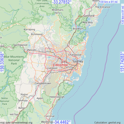
Lidcombe GPS coordinates[2]
33° 51' 51.696" South, 151° 2' 22.92" East
| Map corner | latitude | longitude |
|---|---|---|
| Upper-left | -33.27852°, | 150.33658° |
| Center: | -33.86436°, | 151.0397° |
| Lower-right: | -34.4462°, | 151.74283° |
| Map W x H: | 129.8×129.8 km | = 80.7×80.7mi |
| max Lat: | -10.58257° ⇑54.3% North |
| Lidcombe: | -33.86436° |
| min Lat: | ⇓45.7% South -43.31423° |
| min Long | Lidcombe | max Long |
| 113.53327° | 151.0397° | 153.61246° |
| W 68.4%⇐ | ⇒31.6% E |
Elevation
Elevation of Lidcombe is 18 m = 59 ft, and this is 104 m = 341 ft below average elevation for this country.
| Max E: |
1715 m = 5627 ft | 76.1% |
| Avg. | 122 m = 400 ft | |
| Lidcombe | 18 m = 59 ft | |
Min E: |
-2 m = -7 ft | 23.9% |
See also: Australia elevation on elevation.city.
Geographical zone
Lidcombe is located in South temperate zone (between Tropic of Capricorn and the Antarctic Circle). Distance of this Southern Tropic circle is 1159.4 km =720.4 mi to North.| Distance of | km | miles | from Lidcombe |
|---|---|---|---|
| Equator | 3765.4 | 2339.7 | to North |
| Tropic Capricorn | 1159.4 | 720.4 | to North |
| Antarctic Circle | 3635.8 | 2259.2 | to South |
| South Pole | 6241.7 | 3878.4 | to South |


Nearby cities:
15 places around Lidcombe: (largest is in red/bold)
• Auburn
1.7 km =1.1 mi,  339°
339°
• Berala
1 km =0.6 mi,  212°
212°
• Birrong
3.6 km =2.2 mi, 209°
• Chester Hill
4.1 km =2.5 mi,  246°
246°
• Granville
4 km =2.5 mi,  311°
311°
• Homebush
4 km =2.5 mi,  93°
93°
• Homebush West
2.5 km =1.6 mi, 85°
• Newington
3.6 km =2.2 mi,  26°
26°
• Potts Hill
3.2 km =2 mi,  189°
189°
• Regents Park
3 km =1.9 mi,  225°
225°
• Sefton
3.7 km =2.3 mi, 226°
• Silverwater
3.5 km =2.2 mi,  11°
11°
• South Granville
2.8 km =1.7 mi,  283°
283°
• Strathfield
4.1 km =2.5 mi,  116°
116°
• Sydney Olympic Park
3.1 km =1.9 mi,  58°
58°
Sources, notices
• [Note1] Compared only with cities in Australia existing in our database
• [Src1] Map data: © OpenStreetMap contributors (CC-BY-SA)
• [Src2] Other city data from geonames.org with taken over terms of usage.
• [Src3] Geographical zone / Annual Mean Temperature by Robert A. Rohde @ Wikipedia
