Launceston geodata
Launceston (Tasmania) is a seat of a second-order administrative division; located in Australia in Australia/Hobart (GMT+11) time zone. With population of 106,153 people, there are 17 cities with bigger population in this country. Compared to other cities in Australia, 97.5% of cities are located further ↑North; 52.4% of cities are located further →East and 65.6% of cities have lower elevation than Launceston. Note1


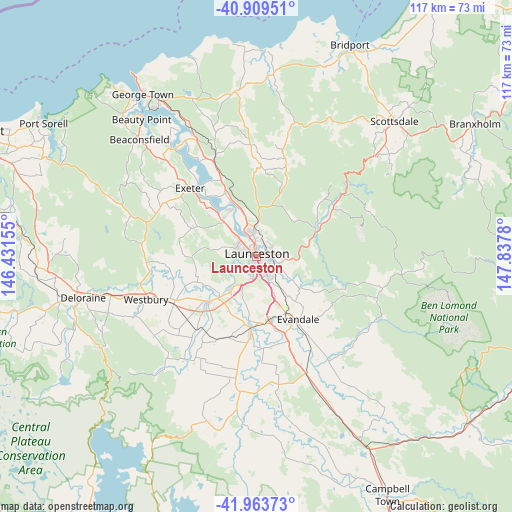
Launceston GPS coordinates[2]
41° 26' 19.536" South, 147° 8' 4.812" East
| Map corner | latitude | longitude |
|---|---|---|
| Upper-left | -40.90951°, | 146.43155° |
| Center: | -41.43876°, | 147.13467° |
| Lower-right: | -41.96373°, | 147.8378° |
| Map W x H: | 117.2×117.2 km | = 72.8×72.8mi |
| max Lat: | -10.58257° ⇑97.5% North |
| Launceston: | -41.43876° |
| min Lat: | ⇓2.5% South -43.31423° |
| min Long | Launceston | max Long |
| 113.53327° | 147.13467° | 153.61246° |
| W 47.6%⇐ | ⇒52.4% E |
Elevation
Elevation of Launceston is 82 m = 269 ft, and this is 40 m = 131 ft below average elevation for this country.
| Max E: |
1715 m = 5627 ft | 34.4% |
| Avg. | 122 m = 400 ft | |
| Launceston | 82 m = 269 ft | |
Min E: |
-2 m = -7 ft | 65.6% |
See also: Launceston elevation on elevation.city.
Geographical zone
Launceston is located in South temperate zone (between Tropic of Capricorn and the Antarctic Circle). Distance of this Southern Tropic circle is 2001.6 km =1243.7 mi to North.| Distance of | km | miles | from Launceston |
|---|---|---|---|
| Equator | 4607.6 | 2863 | to North |
| Tropic Capricorn | 2001.6 | 1243.7 | to North |
| Antarctic Circle | 2793.6 | 1735.9 | to South |
| South Pole | 5399.5 | 3355.1 | to South |


Nearby cities:
15 places around Launceston: (largest is in red/bold)
• Blackstone Heights
4.8 km =3 mi,  241°
241°
• East Launceston
1.4 km =0.9 mi,  88°
88°
• Invermay
2 km =1.2 mi,  357°
357°
• Kings Meadows
4.2 km =2.6 mi,  147°
147°
• Launceston city centre
0.6 km =0.4 mi,  24°
24°
• Mowbray
4.3 km =2.7 mi, 18°
• Newstead
2.3 km =1.4 mi,  96°
96°
• Norwood
4.5 km =2.8 mi,  120°
120°
• Prospect Vale
5.3 km =3.3 mi,  208°
208°
• Ravenswood
4.7 km =2.9 mi,  57°
57°
• South Launceston
2 km =1.2 mi, 153°
• Summerhill
3.2 km =2 mi,  189°
189°
• Trevallyn
2.5 km =1.6 mi,  260°
260°
• Waverley
4.3 km =2.7 mi, 85°
• West Launceston
1.4 km =0.9 mi, 192°
Sources, notices
• [Note1] Compared only with cities in Australia existing in our database
• [Src1] Map data: © OpenStreetMap contributors (CC-BY-SA)
• [Src2] Other city data from geonames.org with taken over terms of usage.
• [Src3] Geographical zone / Annual Mean Temperature by Robert A. Rohde @ Wikipedia
