Newstead geodata
Newstead (Tasmania) is a section of populated place; located in Australia in Australia/Hobart (GMT+11) time zone. With population of 4,719 people, there are 1563 cities with bigger population in this country. Compared to other cities in Australia, 97.5% of cities are located further ↑North; 52.2% of cities are located further →East and 90.1% of cities have higher elevation than Newstead. Note1


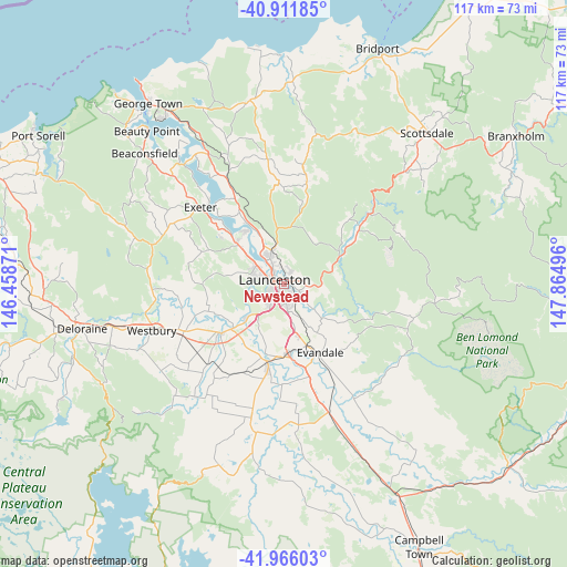
Newstead GPS coordinates[2]
41° 26' 27.888" South, 147° 9' 42.588" East
| Map corner | latitude | longitude |
|---|---|---|
| Upper-left | -40.91185°, | 146.45871° |
| Center: | -41.44108°, | 147.16183° |
| Lower-right: | -41.96603°, | 147.86496° |
| Map W x H: | 117.2×117.2 km | = 72.8×72.8mi |
| max Lat: | -10.58257° ⇑97.5% North |
| Newstead: | -41.44108° |
| min Lat: | ⇓2.5% South -43.31423° |
| min Long | Newstead | max Long |
| 113.53327° | 147.16183° | 153.61246° |
| W 47.8%⇐ | ⇒52.2% E |
Elevation
Elevation of Newstead is 9 m = 30 ft, and this is 113 m = 371 ft below average elevation for this country.
| Max E: |
1715 m = 5627 ft | 90.1% |
| Avg. | 122 m = 400 ft | |
| Newstead | 9 m = 30 ft | |
Min E: |
-2 m = -7 ft | 9.9% |
See also: Australia elevation on elevation.city.
Geographical zone
Newstead is located in South temperate zone (between Tropic of Capricorn and the Antarctic Circle). Distance of this Southern Tropic circle is 2001.9 km =1243.9 mi to North.| Distance of | km | miles | from Newstead |
|---|---|---|---|
| Equator | 4607.8 | 2863.2 | to North |
| Tropic Capricorn | 2001.9 | 1243.9 | to North |
| Antarctic Circle | 2793.4 | 1735.7 | to South |
| South Pole | 5399.2 | 3354.9 | to South |


Nearby cities:
15 places around Newstead: (largest is in red/bold)
• East Launceston
0.9 km =0.6 mi,  288°
288°
• Invermay
3.3 km =2.1 mi,  314°
314°
• Kings Meadows
3.3 km =2.1 mi,  179°
179°
• Launceston
2.3 km =1.4 mi,  276°
276°
• Launceston city centre
2.2 km =1.4 mi, 292°
• Mowbray
4.4 km =2.7 mi,  347°
347°
• Norwood
2.6 km =1.6 mi,  141°
141°
• Ravenswood
3.3 km =2.1 mi,  31°
31°
• Saint Leonards
3.6 km =2.2 mi,  118°
118°
• South Launceston
2.1 km =1.3 mi,  221°
221°
• Summerhill
4.1 km =2.5 mi, 223°
• Trevallyn
4.8 km =3 mi,  268°
268°
• Waverley
2.1 km =1.3 mi,  74°
74°
• West Launceston
2.8 km =1.7 mi,  246°
246°
• Youngtown
4.8 km =3 mi,  171°
171°
Sources, notices
• [Note1] Compared only with cities in Australia existing in our database
• [Src1] Map data: © OpenStreetMap contributors (CC-BY-SA)
• [Src2] Other city data from geonames.org with taken over terms of usage.
• [Src3] Geographical zone / Annual Mean Temperature by Robert A. Rohde @ Wikipedia
