Forster geodata
Forster (New South Wales) is a populated place; located in Australia in Australia/Sydney (GMT+11) time zone. With population of 13,660 people, there are 327 cities with bigger population in this country. Compared to other cities in Australia, 62.8% of cities are located further ↓South; 84.6% of cities are located further ←West and 93.8% of cities have higher elevation than Forster. Note1


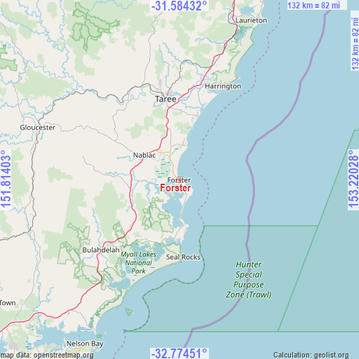
Forster GPS coordinates[2]
32° 10' 52.896" South, 152° 31' 1.74" East
| Map corner | latitude | longitude |
|---|---|---|
| Upper-left | -31.58432°, | 151.81403° |
| Center: | -32.18136°, | 152.51715° |
| Lower-right: | -32.77451°, | 153.22028° |
| Map W x H: | 132.3×132.3 km | = 82.2×82.2mi |
| max Lat: | -10.58257° ⇑37.2% North |
| Forster: | -32.18136° |
| min Lat: | ⇓62.8% South -43.31423° |
| min Long | Forster | max Long |
| 113.53327° | 152.51715° | 153.61246° |
| W 84.6%⇐ | ⇒15.4% E |
Elevation
Elevation of Forster is 7 m = 23 ft, and this is 115 m = 377 ft below average elevation for this country.
| Max E: |
1715 m = 5627 ft | 93.8% |
| Avg. | 122 m = 400 ft | |
| Forster | 7 m = 23 ft | |
Min E: |
-2 m = -7 ft | 6.2% |
See also: Australia elevation on elevation.city.
Geographical zone
Forster is located in South temperate zone (between Tropic of Capricorn and the Antarctic Circle). Distance of this Southern Tropic circle is 972.3 km =604.2 mi to North.| Distance of | km | miles | from Forster |
|---|---|---|---|
| Equator | 3578.2 | 2223.4 | to North |
| Tropic Capricorn | 972.3 | 604.2 | to North |
| Antarctic Circle | 3822.9 | 2375.4 | to South |
| South Pole | 6428.8 | 3994.7 | to South |


Nearby cities:
15 places around Forster: (largest is in red/bold)
• Black Head
12.3 km =7.6 mi,  7°
7°
• Coomba Park
8.4 km =5.2 mi,  222°
222°
• Diamond Beach
15.4 km =9.6 mi, 6°
• Failford
12 km =7.5 mi,  326°
326°
• Green Point
7.6 km =4.7 mi,  179°
179°
• Hallidays Point
12.9 km =8 mi,  353°
353°
• Nabiac
16.2 km =10.1 mi,  304°
304°
• Old Bar
24.5 km =15.2 mi,  15°
15°
• Rainbow Flat
16.8 km =10.4 mi, 349°
• Red Head
13.9 km =8.6 mi, 7°
• Smiths Lake
22.2 km =13.8 mi, 183°
• Tallwoods Village
14 km =8.7 mi,  357°
357°
• Tinonee
28.9 km =18 mi,  340°
340°
• Tuncurry
1.9 km =1.2 mi,  293°
293°
• Wallabi Point
21.3 km =13.2 mi, 13°
Sources, notices
• [Note1] Compared only with cities in Australia existing in our database
• [Src1] Map data: © OpenStreetMap contributors (CC-BY-SA)
• [Src2] Other city data from geonames.org with taken over terms of usage.
• [Src3] Geographical zone / Annual Mean Temperature by Robert A. Rohde @ Wikipedia
