Smiths Lake geodata
Smiths Lake (New South Wales) is a populated place; located in Australia in Australia/Sydney (GMT+11) time zone. With population of 1,198 people, there are 3585 cities with bigger population in this country. Compared to other cities in Australia, 61.9% of cities are located further ↓South; 84.6% of cities are located further ←West and 55% of cities have lower elevation than Smiths Lake. Note1


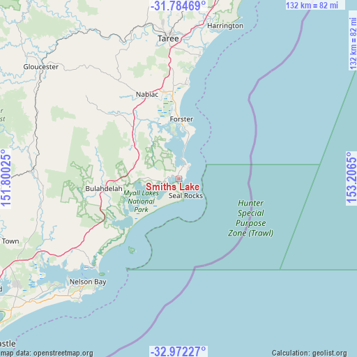
Smiths Lake GPS coordinates[2]
32° 22' 49.548" South, 152° 30' 12.132" East
| Map corner | latitude | longitude |
|---|---|---|
| Upper-left | -31.78469°, | 151.80025° |
| Center: | -32.38043°, | 152.50337° |
| Lower-right: | -32.97227°, | 153.2065° |
| Map W x H: | 132×132 km | = 82×82mi |
| max Lat: | -10.58257° ⇑38.1% North |
| Smiths Lake: | -32.38043° |
| min Lat: | ⇓61.9% South -43.31423° |
| min Long | Smiths Lake | max Long |
| 113.53327° | 152.50337° | 153.61246° |
| W 84.6%⇐ | ⇒15.4% E |
Elevation
Elevation of Smiths Lake is 53 m = 174 ft, and this is 69 m = 226 ft below average elevation for this country.
| Max E: |
1715 m = 5627 ft | 45% |
| Avg. | 122 m = 400 ft | |
| Smiths Lake | 53 m = 174 ft | |
Min E: |
-2 m = -7 ft | 55% |
See also: Australia elevation on elevation.city.
Geographical zone
Smiths Lake is located in South temperate zone (between Tropic of Capricorn and the Antarctic Circle). Distance of this Southern Tropic circle is 994.4 km =617.9 mi to North.| Distance of | km | miles | from Smiths Lake |
|---|---|---|---|
| Equator | 3600.4 | 2237.2 | to North |
| Tropic Capricorn | 994.4 | 617.9 | to North |
| Antarctic Circle | 3800.8 | 2361.7 | to South |
| South Pole | 6406.7 | 3980.9 | to South |


Nearby cities:
15 places around Smiths Lake: (largest is in red/bold)
• Black Head
34.5 km =21.4 mi,  4°
4°
• Bulahdelah
27.5 km =17.1 mi,  263°
263°
• Coomba Park
16.5 km =10.3 mi,  344°
344°
• Diamond Beach
37.6 km =23.4 mi, 4°
• Failford
32.5 km =20.2 mi,  350°
350°
• Forster
22.2 km =13.8 mi, 3°
• Green Point
14.6 km =9.1 mi,  5°
5°
• Hallidays Point
34.9 km =21.7 mi,  359°
359°
• Hawks Nest
44.1 km =27.4 mi,  223°
223°
• Nabiac
33.6 km =20.9 mi, 339°
• Rainbow Flat
38.6 km =24 mi, 357°
• Red Head
36.1 km =22.4 mi, 4°
• Tallwoods Village
36.2 km =22.5 mi, 1°
• Tuncurry
22.9 km =14.2 mi, 358°
• Wallabi Point
43.3 km =26.9 mi, 8°
Sources, notices
• [Note1] Compared only with cities in Australia existing in our database
• [Src1] Map data: © OpenStreetMap contributors (CC-BY-SA)
• [Src2] Other city data from geonames.org with taken over terms of usage.
• [Src3] Geographical zone / Annual Mean Temperature by Robert A. Rohde @ Wikipedia
