Epping geodata
Epping (New South Wales) is a section of populated place; located in Australia in Australia/Sydney (GMT+11) time zone. With population of 23,435 people, there are 117 cities with bigger population in this country. Compared to other cities in Australia, 51% of cities are located further ↑North; 69.3% of cities are located further ←West and 69.1% of cities have lower elevation than Epping. Note1


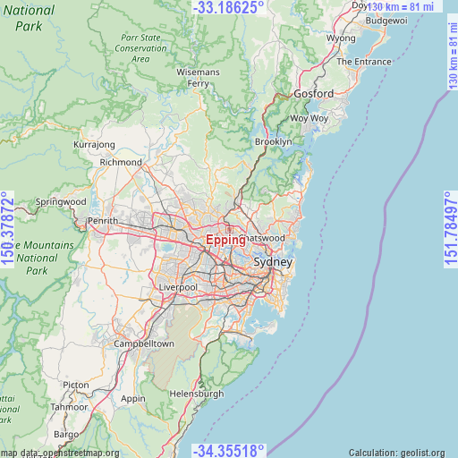
Epping GPS coordinates[2]
33° 46' 21.756" South, 151° 4' 54.624" East
| Map corner | latitude | longitude |
|---|---|---|
| Upper-left | -33.18625°, | 150.37872° |
| Center: | -33.77271°, | 151.08184° |
| Lower-right: | -34.35518°, | 151.78497° |
| Map W x H: | 130×130 km | = 80.8×80.8mi |
| max Lat: | -10.58257° ⇑51% North |
| Epping: | -33.77271° |
| min Lat: | ⇓49% South -43.31423° |
| min Long | Epping | max Long |
| 113.53327° | 151.08184° | 153.61246° |
| W 69.3%⇐ | ⇒30.7% E |
Elevation
Elevation of Epping is 97 m = 318 ft, and this is 25 m = 82 ft below average elevation for this country.
| Max E: |
1715 m = 5627 ft | 30.9% |
| Avg. | 122 m = 400 ft | |
| Epping | 97 m = 318 ft | |
Min E: |
-2 m = -7 ft | 69.1% |
See also: Australia elevation on elevation.city.
Geographical zone
Epping is located in South temperate zone (between Tropic of Capricorn and the Antarctic Circle). Distance of this Southern Tropic circle is 1149.3 km =714.1 mi to North.| Distance of | km | miles | from Epping |
|---|---|---|---|
| Equator | 3755.2 | 2333.4 | to North |
| Tropic Capricorn | 1149.3 | 714.1 | to North |
| Antarctic Circle | 3646 | 2265.5 | to South |
| South Pole | 6251.9 | 3884.7 | to South |


Nearby cities:
15 places around Epping: (largest is in red/bold)
• Beecroft
3 km =1.9 mi,  328°
328°
• Carlingford
3.2 km =2 mi,  249°
249°
• Denistone
3 km =1.9 mi,  164°
164°
• Denistone East
3 km =1.9 mi,  150°
150°
• Denistone West
3.1 km =1.9 mi,  189°
189°
• Dundas Valley
3.2 km =2 mi,  237°
237°
• Eastwood
2.1 km =1.3 mi,  183°
183°
• Macquarie Park
4.3 km =2.7 mi,  102°
102°
• Marsfield
2.3 km =1.4 mi, 104°
• North Epping
1.8 km =1.1 mi,  33°
33°
• Pennant Hills
4 km =2.5 mi,  347°
347°
• South Turramurra
3.8 km =2.4 mi,  47°
47°
• Thornleigh
4.5 km =2.8 mi,  356°
356°
• West Pennant Hills
4.4 km =2.7 mi,  313°
313°
• West Ryde
3.7 km =2.3 mi, 191°
Sources, notices
• [Note1] Compared only with cities in Australia existing in our database
• [Src1] Map data: © OpenStreetMap contributors (CC-BY-SA)
• [Src2] Other city data from geonames.org with taken over terms of usage.
• [Src3] Geographical zone / Annual Mean Temperature by Robert A. Rohde @ Wikipedia
