Carlingford geodata
Carlingford (New South Wales) is a section of populated place; located in Australia in Australia/Sydney (GMT+11) time zone. With population of 24,131 people, there are 110 cities with bigger population in this country. Compared to other cities in Australia, 51.3% of cities are located further ↑North; 68.6% of cities are located further ←West and 70.4% of cities have lower elevation than Carlingford. Note1


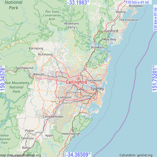
Carlingford GPS coordinates[2]
33° 46' 57.684" South, 151° 2' 55.968" East
| Map corner | latitude | longitude |
|---|---|---|
| Upper-left | -33.1963°, | 150.34576° |
| Center: | -33.78269°, | 151.04888° |
| Lower-right: | -34.36509°, | 151.75201° |
| Map W x H: | 130×130 km | = 80.8×80.8mi |
| max Lat: | -10.58257° ⇑51.3% North |
| Carlingford: | -33.78269° |
| min Lat: | ⇓48.7% South -43.31423° |
| min Long | Carlingford | max Long |
| 113.53327° | 151.04888° | 153.61246° |
| W 68.6%⇐ | ⇒31.4% E |
Elevation
Elevation of Carlingford is 105 m = 344 ft, and this is 17 m = 56 ft below average elevation for this country.
| Max E: |
1715 m = 5627 ft | 29.6% |
| Avg. | 122 m = 400 ft | |
| Carlingford | 105 m = 344 ft | |
Min E: |
-2 m = -7 ft | 70.4% |
See also: Australia elevation on elevation.city.
Geographical zone
Carlingford is located in South temperate zone (between Tropic of Capricorn and the Antarctic Circle). Distance of this Southern Tropic circle is 1150.4 km =714.8 mi to North.| Distance of | km | miles | from Carlingford |
|---|---|---|---|
| Equator | 3756.3 | 2334.1 | to North |
| Tropic Capricorn | 1150.4 | 714.8 | to North |
| Antarctic Circle | 3644.9 | 2264.8 | to South |
| South Pole | 6250.8 | 3884.1 | to South |


Nearby cities:
15 places around Carlingford: (largest is in red/bold)
• Beecroft
4 km =2.5 mi,  21°
21°
• Denistone
4.2 km =2.6 mi,  114°
114°
• Denistone West
3.2 km =2 mi,  128°
128°
• Dundas Valley
0.7 km =0.4 mi,  150°
150°
• Eastwood
3.1 km =1.9 mi, 109°
• Epping
3.2 km =2 mi,  69°
69°
• Ermington
3.6 km =2.2 mi,  171°
171°
• Melrose Park
4.2 km =2.6 mi, 149°
• North Parramatta
4.6 km =2.9 mi,  254°
254°
• North Rocks
3.2 km =2 mi,  291°
291°
• Oatlands
2.5 km =1.6 mi,  233°
233°
• Rydalmere
3.7 km =2.3 mi,  196°
196°
• Telopea
1.5 km =0.9 mi,  220°
220°
• West Pennant Hills
4.1 km =2.5 mi,  358°
358°
• West Ryde
3.4 km =2.1 mi,  137°
137°
Sources, notices
• [Note1] Compared only with cities in Australia existing in our database
• [Src1] Map data: © OpenStreetMap contributors (CC-BY-SA)
• [Src2] Other city data from geonames.org with taken over terms of usage.
• [Src3] Geographical zone / Annual Mean Temperature by Robert A. Rohde @ Wikipedia
