Elsternwick geodata
Elsternwick (Victoria) is a populated place; located in Australia in Australia/Melbourne (GMT+11) time zone. With population of 10,160 people, there are 579 cities with bigger population in this country. Compared to other cities in Australia, 90.1% of cities are located further ↑North; 66.3% of cities are located further →East and 70.9% of cities have higher elevation than Elsternwick. Note1


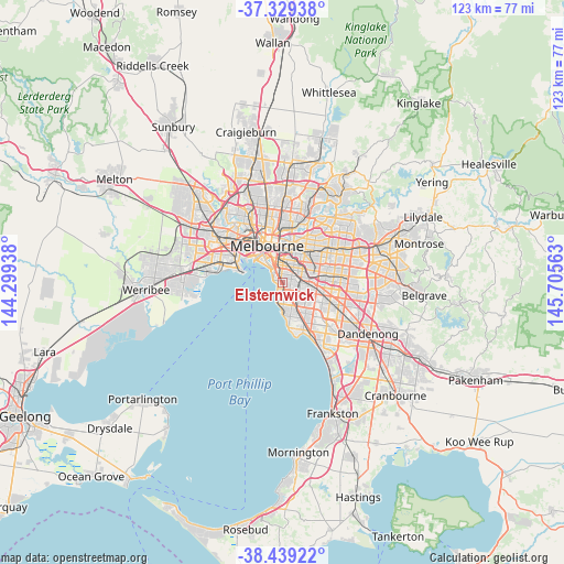
Elsternwick GPS coordinates[2]
37° 53' 11.004" South, 145° 0' 9" East
| Map corner | latitude | longitude |
|---|---|---|
| Upper-left | -37.32938°, | 144.29938° |
| Center: | -37.88639°, | 145.0025° |
| Lower-right: | -38.43922°, | 145.70563° |
| Map W x H: | 123.4×123.4 km | = 76.7×76.7mi |
| max Lat: | -10.58257° ⇑90.1% North |
| Elsternwick: | -37.88639° |
| min Lat: | ⇓9.9% South -43.31423° |
| min Long | Elsternwick | max Long |
| 113.53327° | 145.0025° | 153.61246° |
| W 33.7%⇐ | ⇒66.3% E |
Elevation
Elevation of Elsternwick is 22 m = 72 ft, and this is 100 m = 328 ft below average elevation for this country.
| Max E: |
1715 m = 5627 ft | 70.9% |
| Avg. | 122 m = 400 ft | |
| Elsternwick | 22 m = 72 ft | |
Min E: |
-2 m = -7 ft | 29.1% |
See also: Australia elevation on elevation.city.
Geographical zone
Elsternwick is located in South temperate zone (between Tropic of Capricorn and the Antarctic Circle). Distance of this Southern Tropic circle is 1606.7 km =998.4 mi to North.| Distance of | km | miles | from Elsternwick |
|---|---|---|---|
| Equator | 4212.6 | 2617.6 | to North |
| Tropic Capricorn | 1606.7 | 998.4 | to North |
| Antarctic Circle | 3188.6 | 1981.3 | to South |
| South Pole | 5794.5 | 3600.5 | to South |


Nearby cities:
15 places around Elsternwick: (largest is in red/bold)
• Balaclava
2.2 km =1.4 mi,  354°
354°
• Brighton
2.1 km =1.3 mi,  179°
179°
• Brighton East
2.2 km =1.4 mi,  143°
143°
• Caulfield
1.8 km =1.1 mi,  76°
76°
• Caulfield East
3.5 km =2.2 mi, 80°
• Caulfield North
2.4 km =1.5 mi,  54°
54°
• Caulfield South
2.3 km =1.4 mi,  116°
116°
• Elwood
1.8 km =1.1 mi,  284°
284°
• Gardenvale
1.4 km =0.9 mi,  155°
155°
• Malvern
3.5 km =2.2 mi,  40°
40°
• North Brighton
2.3 km =1.4 mi,  173°
173°
• Ormond
3.1 km =1.9 mi, 119°
• Ripponlea
0.4 km =0.2 mi,  327°
327°
• Saint Kilda
2.8 km =1.7 mi,  317°
317°
• St Kilda East
2.3 km =1.4 mi, 354°
Sources, notices
• [Note1] Compared only with cities in Australia existing in our database
• [Src1] Map data: © OpenStreetMap contributors (CC-BY-SA)
• [Src2] Other city data from geonames.org with taken over terms of usage.
• [Src3] Geographical zone / Annual Mean Temperature by Robert A. Rohde @ Wikipedia
