Collingwood geodata
Collingwood (Victoria) is a section of populated place; located in Australia in Australia/Melbourne (GMT+11) time zone. With population of 8,493 people, there are 765 cities with bigger population in this country. Compared to other cities in Australia, 87.7% of cities are located further ↑North; 66.6% of cities are located further →East and 67.2% of cities have higher elevation than Collingwood. Note1


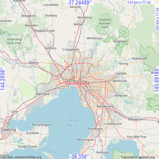
Collingwood GPS coordinates[2]
37° 48' 9.108" South, 144° 59' 19.392" East
| Map corner | latitude | longitude |
|---|---|---|
| Upper-left | -37.24489°, | 144.2856° |
| Center: | -37.80253°, | 144.98872° |
| Lower-right: | -38.356°, | 145.69185° |
| Map W x H: | 123.5×123.5 km | = 76.7×76.7mi |
| max Lat: | -10.58257° ⇑87.7% North |
| Collingwood: | -37.80253° |
| min Lat: | ⇓12.3% South -43.31423° |
| min Long | Collingwood | max Long |
| 113.53327° | 144.98872° | 153.61246° |
| W 33.4%⇐ | ⇒66.6% E |
Elevation
Elevation of Collingwood is 25 m = 82 ft, and this is 97 m = 318 ft below average elevation for this country.
| Max E: |
1715 m = 5627 ft | 67.2% |
| Avg. | 122 m = 400 ft | |
| Collingwood | 25 m = 82 ft | |
Min E: |
-2 m = -7 ft | 32.8% |
See also: Australia elevation on elevation.city.
Geographical zone
Collingwood is located in South temperate zone (between Tropic of Capricorn and the Antarctic Circle). Distance of this Southern Tropic circle is 1597.3 km =992.5 mi to North.| Distance of | km | miles | from Collingwood |
|---|---|---|---|
| Equator | 4203.2 | 2611.7 | to North |
| Tropic Capricorn | 1597.3 | 992.5 | to North |
| Antarctic Circle | 3197.9 | 1987.1 | to South |
| South Pole | 5803.8 | 3606.3 | to South |


Nearby cities:
15 places around Collingwood: (largest is in red/bold)
• Abbotsford
1 km =0.6 mi,  74°
74°
• Carlton
2 km =1.2 mi,  278°
278°
• Carlton North
2.3 km =1.4 mi,  314°
314°
• Clifton Hill
0.8 km =0.5 mi,  48°
48°
• Cremorne
3.3 km =2.1 mi,  172°
172°
• East Melbourne
1.6 km =1 mi,  182°
182°
• Fairfield
3.6 km =2.2 mi, 45°
• Fitzroy
1 km =0.6 mi,  296°
296°
• Fitzroy North
1.8 km =1.1 mi,  330°
330°
• Melbourne
2.6 km =1.6 mi,  240°
240°
• Melbourne City Centre
2.4 km =1.5 mi,  234°
234°
• Princes Hill
3 km =1.9 mi,  319°
319°
• Richmond
2.1 km =1.3 mi,  146°
146°
• Southbank
3.1 km =1.9 mi,  223°
223°
• West Melbourne
3.5 km =2.2 mi,  256°
256°
Sources, notices
• [Note1] Compared only with cities in Australia existing in our database
• [Src1] Map data: © OpenStreetMap contributors (CC-BY-SA)
• [Src2] Other city data from geonames.org with taken over terms of usage.
• [Src3] Geographical zone / Annual Mean Temperature by Robert A. Rohde @ Wikipedia
