Southbank geodata
Southbank (Victoria) is a section of populated place; located in Australia in Australia/Melbourne (GMT+11) time zone. With population of 22,397 people, there are 133 cities with bigger population in this country. Compared to other cities in Australia, 88.4% of cities are located further ↑North; 67% of cities are located further →East and 80.4% of cities have higher elevation than Southbank. Note1


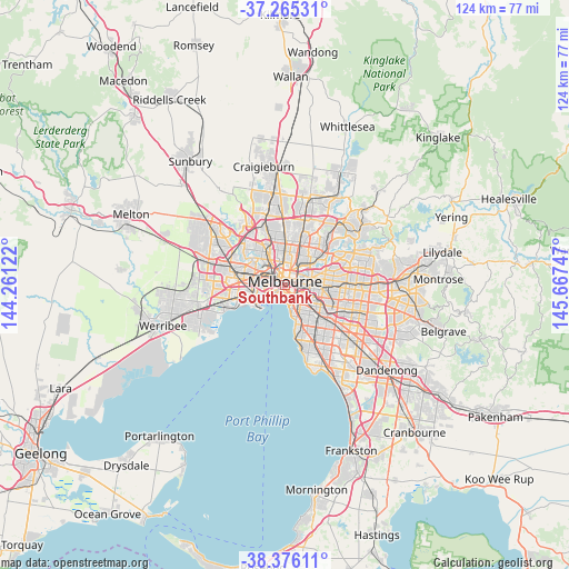
Southbank GPS coordinates[2]
37° 49' 22.08" South, 144° 57' 51.624" East
| Map corner | latitude | longitude |
|---|---|---|
| Upper-left | -37.26531°, | 144.26122° |
| Center: | -37.8228°, | 144.96434° |
| Lower-right: | -38.37611°, | 145.66747° |
| Map W x H: | 123.5×123.5 km | = 76.7×76.7mi |
| max Lat: | -10.58257° ⇑88.4% North |
| Southbank: | -37.8228° |
| min Lat: | ⇓11.6% South -43.31423° |
| min Long | Southbank | max Long |
| 113.53327° | 144.96434° | 153.61246° |
| W 33%⇐ | ⇒67% E |
Elevation
Elevation of Southbank is 15 m = 49 ft, and this is 107 m = 351 ft below average elevation for this country.
| Max E: |
1715 m = 5627 ft | 80.4% |
| Avg. | 122 m = 400 ft | |
| Southbank | 15 m = 49 ft | |
Min E: |
-2 m = -7 ft | 19.6% |
See also: Australia elevation on elevation.city.
Geographical zone
Southbank is located in South temperate zone (between Tropic of Capricorn and the Antarctic Circle). Distance of this Southern Tropic circle is 1599.6 km =993.9 mi to North.| Distance of | km | miles | from Southbank |
|---|---|---|---|
| Equator | 4205.5 | 2613.2 | to North |
| Tropic Capricorn | 1599.6 | 993.9 | to North |
| Antarctic Circle | 3195.7 | 1985.7 | to South |
| South Pole | 5801.6 | 3604.9 | to South |


Nearby cities:
15 places around Southbank: (largest is in red/bold)
• Albert Park
2.3 km =1.4 mi,  208°
208°
• Carlton
2.5 km =1.6 mi,  4°
4°
• Collingwood
3.1 km =1.9 mi,  43°
43°
• Cremorne
2.8 km =1.7 mi,  111°
111°
• Docklands
1.5 km =0.9 mi,  305°
305°
• East Melbourne
2.2 km =1.4 mi,  71°
71°
• Fitzroy
3 km =1.9 mi,  24°
24°
• Melbourne
1 km =0.6 mi,  354°
354°
• Melbourne City Centre
0.9 km =0.6 mi,  12°
12°
• Middle Park
3.2 km =2 mi,  183°
183°
• Port Melbourne
2.7 km =1.7 mi,  226°
226°
• South Melbourne
1.2 km =0.7 mi,  170°
170°
• South Wharf
1.1 km =0.7 mi,  255°
255°
• South Yarra
2.9 km =1.8 mi,  125°
125°
• West Melbourne
1.9 km =1.2 mi,  318°
318°
Sources, notices
• [Note1] Compared only with cities in Australia existing in our database
• [Src1] Map data: © OpenStreetMap contributors (CC-BY-SA)
• [Src2] Other city data from geonames.org with taken over terms of usage.
• [Src3] Geographical zone / Annual Mean Temperature by Robert A. Rohde @ Wikipedia
