Canadian geodata
Canadian (Victoria) is a section of populated place; located in Australia in Australia/Melbourne (GMT+11) time zone. With population of 3,477 people, there are 1997 cities with bigger population in this country. Compared to other cities in Australia, 83.2% of cities are located further ↑North; 72.7% of cities are located further →East and 92.3% of cities have lower elevation than Canadian. Note1


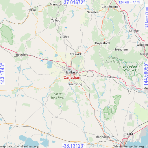
Canadian GPS coordinates[2]
37° 34' 33.816" South, 143° 52' 38.712" East
| Map corner | latitude | longitude |
|---|---|---|
| Upper-left | -37.01672°, | 143.1743° |
| Center: | -37.57606°, | 143.87742° |
| Lower-right: | -38.13123°, | 144.58055° |
| Map W x H: | 123.9×123.9 km | = 77×77mi |
| max Lat: | -10.58257° ⇑83.2% North |
| Canadian: | -37.57606° |
| min Lat: | ⇓16.8% South -43.31423° |
| min Long | Canadian | max Long |
| 113.53327° | 143.87742° | 153.61246° |
| W 27.3%⇐ | ⇒72.7% E |
Elevation
Elevation of Canadian is 447 m = 1467 ft, and this is 325 m = 1066 ft above average elevation for this country.
| Max E: |
1715 m = 5627 ft | 7.7% |
| Canadian | 447 m 1467 ft | |
| Avg. | 122 m = 400 ft | |
Min E: |
-2 m = -7 ft | 92.3% |
See also: Australia elevation on elevation.city.
Geographical zone
Canadian is located in South temperate zone (between Tropic of Capricorn and the Antarctic Circle). Distance of this Southern Tropic circle is 1572.1 km =976.9 mi to North.| Distance of | km | miles | from Canadian |
|---|---|---|---|
| Equator | 4178.1 | 2596.2 | to North |
| Tropic Capricorn | 1572.1 | 976.9 | to North |
| Antarctic Circle | 3223.1 | 2002.7 | to South |
| South Pole | 5829 | 3622 | to South |


Nearby cities:
15 places around Canadian: (largest is in red/bold)
• Ballarat
2.7 km =1.7 mi,  294°
294°
• Ballarat Central
2.8 km =1.7 mi,  303°
303°
• Ballarat East
1.4 km =0.9 mi,  317°
317°
• Ballarat North
4 km =2.5 mi,  346°
346°
• Black Hill
3 km =1.9 mi,  341°
341°
• Brown Hill
4.7 km =2.9 mi,  45°
45°
• Eureka
1.3 km =0.8 mi,  19°
19°
• Golden Point
0.8 km =0.5 mi,  279°
279°
• Lake Wendouree
3.9 km =2.4 mi, 317°
• Mount Clear
2.7 km =1.7 mi,  168°
168°
• Mount Pleasant
1.2 km =0.7 mi,  229°
229°
• Nerrina
2.9 km =1.8 mi,  10°
10°
• Redan
3.4 km =2.1 mi,  269°
269°
• Sebastopol
3.5 km =2.2 mi,  252°
252°
• Soldiers Hill
3.4 km =2.1 mi,  330°
330°
Sources, notices
• [Note1] Compared only with cities in Australia existing in our database
• [Src1] Map data: © OpenStreetMap contributors (CC-BY-SA)
• [Src2] Other city data from geonames.org with taken over terms of usage.
• [Src3] Geographical zone / Annual Mean Temperature by Robert A. Rohde @ Wikipedia
