Brown Hill geodata
Brown Hill (Victoria) is a section of populated place; located in Australia in Australia/Melbourne (GMT+11) time zone. With population of 3,078 people, there are 2207 cities with bigger population in this country. Compared to other cities in Australia, 82.9% of cities are located further ↑North; 72.6% of cities are located further →East and 92.6% of cities have lower elevation than Brown Hill. Note1


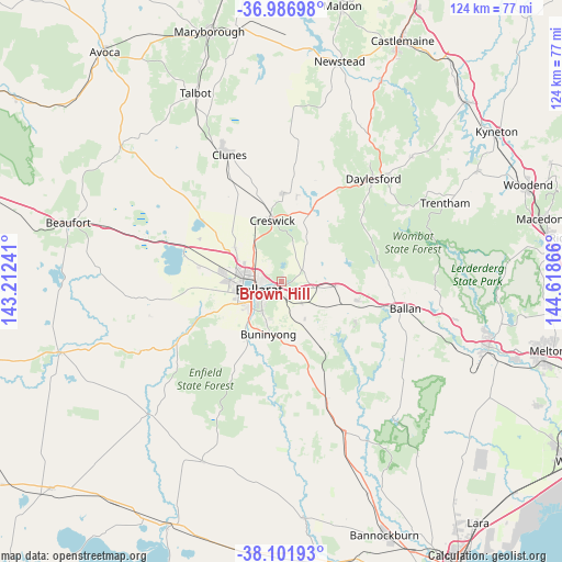
Brown Hill GPS coordinates[2]
37° 32' 47.544" South, 143° 54' 55.908" East
| Map corner | latitude | longitude |
|---|---|---|
| Upper-left | -36.98698°, | 143.21241° |
| Center: | -37.54654°, | 143.91553° |
| Lower-right: | -38.10193°, | 144.61866° |
| Map W x H: | 124×124 km | = 77.1×77.1mi |
| max Lat: | -10.58257° ⇑82.9% North |
| Brown Hill: | -37.54654° |
| min Lat: | ⇓17.1% South -43.31423° |
| min Long | Brown Hill | max Long |
| 113.53327° | 143.91553° | 153.61246° |
| W 27.4%⇐ | ⇒72.6% E |
Elevation
Elevation of Brown Hill is 457 m = 1499 ft, and this is 335 m = 1099 ft above average elevation for this country.
| Max E: |
1715 m = 5627 ft | 7.4% |
| Brown Hill | 457 m 1499 ft | |
| Avg. | 122 m = 400 ft | |
Min E: |
-2 m = -7 ft | 92.6% |
See also: Australia elevation on elevation.city.
Geographical zone
Brown Hill is located in South temperate zone (between Tropic of Capricorn and the Antarctic Circle). Distance of this Southern Tropic circle is 1568.9 km =974.9 mi to North.| Distance of | km | miles | from Brown Hill |
|---|---|---|---|
| Equator | 4174.8 | 2594.1 | to North |
| Tropic Capricorn | 1568.9 | 974.9 | to North |
| Antarctic Circle | 3226.4 | 2004.8 | to South |
| South Pole | 5832.3 | 3624 | to South |


Nearby cities:
15 places around Brown Hill: (largest is in red/bold)
• Ballarat
6.2 km =3.9 mi,  249°
249°
• Ballarat Central
6 km =3.7 mi, 253°
• Ballarat East
4.9 km =3 mi,  242°
242°
• Ballarat North
4.4 km =2.7 mi,  278°
278°
• Black Hill
4.3 km =2.7 mi,  264°
264°
• Canadian
4.7 km =2.9 mi,  225°
225°
• Eureka
3.5 km =2.2 mi, 235°
• Golden Point
5.2 km =3.2 mi, 232°
• Invermay
4.5 km =2.8 mi,  318°
318°
• Invermay Park
5.4 km =3.4 mi,  289°
289°
• Lake Wendouree
6 km =3.7 mi,  266°
266°
• Mount Pleasant
5.9 km =3.7 mi, 226°
• Nerrina
2.9 km =1.8 mi, 262°
• Soldiers Hill
5 km =3.1 mi, 266°
• Warrenheip
2.7 km =1.7 mi,  144°
144°
Sources, notices
• [Note1] Compared only with cities in Australia existing in our database
• [Src1] Map data: © OpenStreetMap contributors (CC-BY-SA)
• [Src2] Other city data from geonames.org with taken over terms of usage.
• [Src3] Geographical zone / Annual Mean Temperature by Robert A. Rohde @ Wikipedia
