Caloundra geodata
Caloundra (Queensland) is a populated place; located in Australia in Australia/Brisbane (GMT+10) time zone. With population of 4,649 people, there are 1585 cities with bigger population in this country. Compared to other cities in Australia, 85.9% of cities are located further ↓South; 95.4% of cities are located further ←West and 91.8% of cities have higher elevation than Caloundra. Note1


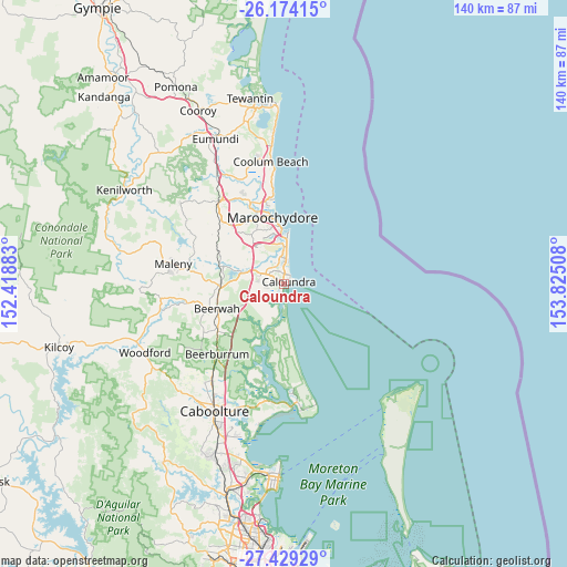
Caloundra GPS coordinates[2]
26° 48' 12.456" South, 153° 7' 19.02" East
| Map corner | latitude | longitude |
|---|---|---|
| Upper-left | -26.17415°, | 152.41883° |
| Center: | -26.80346°, | 153.12195° |
| Lower-right: | -27.42929°, | 153.82508° |
| Map W x H: | 139.6×139.6 km | = 86.7×86.7mi |
| max Lat: | -10.58257° ⇑14.1% North |
| Caloundra: | -26.80346° |
| min Lat: | ⇓85.9% South -43.31423° |
| min Long | Caloundra | max Long |
| 113.53327° | 153.12195° | 153.61246° |
| W 95.4%⇐ | ⇒4.6% E |
Elevation
Elevation of Caloundra is 8 m = 26 ft, and this is 114 m = 374 ft below average elevation for this country.
| Max E: |
1715 m = 5627 ft | 91.8% |
| Avg. | 122 m = 400 ft | |
| Caloundra | 8 m = 26 ft | |
Min E: |
-2 m = -7 ft | 8.2% |
See also: Australia elevation on elevation.city.
Geographical zone
Caloundra is located in South temperate zone (between Tropic of Capricorn and the Antarctic Circle). Distance of this Southern Tropic circle is 374.3 km =232.6 mi to North.| Distance of | km | miles | from Caloundra |
|---|---|---|---|
| Equator | 2980.3 | 1851.9 | to North |
| Tropic Capricorn | 374.3 | 232.6 | to North |
| Antarctic Circle | 4420.9 | 2747 | to South |
| South Pole | 7026.8 | 4366.2 | to South |


Nearby cities:
15 places around Caloundra: (largest is in red/bold)
• Aroona
2.5 km =1.6 mi,  347°
347°
• Battery Hill
2.8 km =1.7 mi,  14°
14°
• Birtinya
6.7 km =4.2 mi,  357°
357°
• Bokarina
7.3 km =4.5 mi, 6°
• Caloundra West
1.3 km =0.8 mi,  256°
256°
• Currimundi
3.8 km =2.4 mi,  0°
0°
• Dicky Beach
2.7 km =1.7 mi,  35°
35°
• Golden Beach
2 km =1.2 mi,  186°
186°
• Kings Beach
2.1 km =1.3 mi,  84°
84°
• Little Mountain
3.6 km =2.2 mi,  305°
305°
• Meridan Plains
6.8 km =4.2 mi,  299°
299°
• Moffat Beach
2.3 km =1.4 mi,  51°
51°
• Pelican Waters
4 km =2.5 mi,  212°
212°
• Shelly Beach
2.5 km =1.6 mi,  72°
72°
• Wurtulla
5.3 km =3.3 mi, 6°
Sources, notices
• [Note1] Compared only with cities in Australia existing in our database
• [Src1] Map data: © OpenStreetMap contributors (CC-BY-SA)
• [Src2] Other city data from geonames.org with taken over terms of usage.
• [Src3] Geographical zone / Annual Mean Temperature by Robert A. Rohde @ Wikipedia
