Aroona geodata
Aroona (Queensland) is a section of populated place; located in Australia in Australia/Brisbane (GMT+10) time zone. With population of 3,282 people, there are 2077 cities with bigger population in this country. Compared to other cities in Australia, 86.1% of cities are located further ↓South; 95.3% of cities are located further ←West and 61.8% of cities have higher elevation than Aroona. Note1


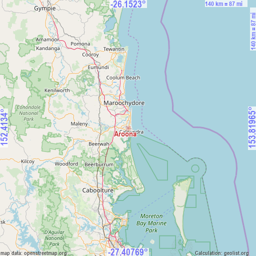
Aroona GPS coordinates[2]
26° 46' 54.228" South, 153° 6' 59.472" East
| Map corner | latitude | longitude |
|---|---|---|
| Upper-left | -26.1523°, | 152.4134° |
| Center: | -26.78173°, | 153.11652° |
| Lower-right: | -27.40769°, | 153.81965° |
| Map W x H: | 139.6×139.6 km | = 86.7×86.7mi |
| max Lat: | -10.58257° ⇑13.9% North |
| Aroona: | -26.78173° |
| min Lat: | ⇓86.1% South -43.31423° |
| min Long | Aroona | max Long |
| 113.53327° | 153.11652° | 153.61246° |
| W 95.3%⇐ | ⇒4.7% E |
Elevation
Elevation of Aroona is 30 m = 98 ft, and this is 92 m = 302 ft below average elevation for this country.
| Max E: |
1715 m = 5627 ft | 61.8% |
| Avg. | 122 m = 400 ft | |
| Aroona | 30 m = 98 ft | |
Min E: |
-2 m = -7 ft | 38.2% |
See also: Australia elevation on elevation.city.
Geographical zone
Aroona is located in South temperate zone (between Tropic of Capricorn and the Antarctic Circle). Distance of this Southern Tropic circle is 371.9 km =231.1 mi to North.| Distance of | km | miles | from Aroona |
|---|---|---|---|
| Equator | 2977.8 | 1850.3 | to North |
| Tropic Capricorn | 371.9 | 231.1 | to North |
| Antarctic Circle | 4423.3 | 2748.5 | to South |
| South Pole | 7029.2 | 4367.7 | to South |


Nearby cities:
15 places around Aroona: (largest is in red/bold)
• Battery Hill
1.3 km =0.8 mi,  75°
75°
• Birtinya
4.3 km =2.7 mi,  3°
3°
• Bokarina
5 km =3.1 mi,  16°
16°
• Caloundra
2.5 km =1.6 mi,  167°
167°
• Caloundra West
2.8 km =1.7 mi,  195°
195°
• Currimundi
1.5 km =0.9 mi, 22°
• Dicky Beach
2.1 km =1.3 mi,  95°
95°
• Golden Beach
4.5 km =2.8 mi,  175°
175°
• Kings Beach
3.4 km =2.1 mi,  130°
130°
• Little Mountain
2.4 km =1.5 mi,  263°
263°
• Meridan Plains
5.5 km =3.4 mi,  279°
279°
• Moffat Beach
2.5 km =1.6 mi,  112°
112°
• Pelican Waters
6 km =3.7 mi, 195°
• Shelly Beach
3.3 km =2.1 mi,  119°
119°
• Wurtulla
3 km =1.9 mi, 22°
Sources, notices
• [Note1] Compared only with cities in Australia existing in our database
• [Src1] Map data: © OpenStreetMap contributors (CC-BY-SA)
• [Src2] Other city data from geonames.org with taken over terms of usage.
• [Src3] Geographical zone / Annual Mean Temperature by Robert A. Rohde @ Wikipedia
