Berkeley geodata
Berkeley (New South Wales) is a section of populated place; located in Australia in Australia/Sydney (GMT+11) time zone. With population of 7,559 people, there are 897 cities with bigger population in this country. Compared to other cities in Australia, 63.2% of cities are located further ↑North; 63.8% of cities are located further ←West and 98.1% of cities have higher elevation than Berkeley. Note1


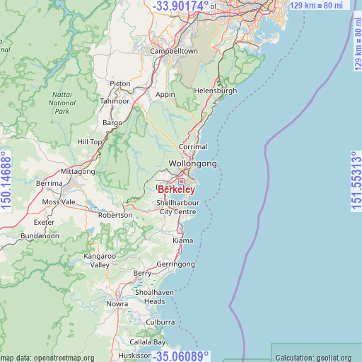
Berkeley GPS coordinates[2]
34° 28' 59.988" South, 150° 51' 0" East
| Map corner | latitude | longitude |
|---|---|---|
| Upper-left | -33.90174°, | 150.14688° |
| Center: | -34.48333°, | 150.85° |
| Lower-right: | -35.06089°, | 151.55313° |
| Map W x H: | 128.9×128.9 km | = 80.1×80.1mi |
| max Lat: | -10.58257° ⇑63.2% North |
| Berkeley: | -34.48333° |
| min Lat: | ⇓36.8% South -43.31423° |
| min Long | Berkeley | max Long |
| 113.53327° | 150.85° | 153.61246° |
| W 63.8%⇐ | ⇒36.2% E |
Elevation
Elevation of Berkeley is 4 m = 13 ft, and this is 118 m = 387 ft below average elevation for this country.
| Max E: |
1715 m = 5627 ft | 98.1% |
| Avg. | 122 m = 400 ft | |
| Berkeley | 4 m = 13 ft | |
Min E: |
-2 m = -7 ft | 1.9% |
See also: Australia elevation on elevation.city.
Geographical zone
Berkeley is located in South temperate zone (between Tropic of Capricorn and the Antarctic Circle). Distance of this Southern Tropic circle is 1228.3 km =763.2 mi to North.| Distance of | km | miles | from Berkeley |
|---|---|---|---|
| Equator | 3834.2 | 2382.5 | to North |
| Tropic Capricorn | 1228.3 | 763.2 | to North |
| Antarctic Circle | 3567 | 2216.4 | to South |
| South Pole | 6172.9 | 3835.7 | to South |


Nearby cities:
15 places around Berkeley: (largest is in red/bold)
• Brownsville
3.6 km =2.2 mi,  270°
270°
• Coniston
4.8 km =3 mi,  39°
39°
• Cordeaux Heights
4.9 km =3 mi,  346°
346°
• Cringila
2.1 km =1.3 mi,  50°
50°
• Farmborough Heights
4.6 km =2.9 mi,  312°
312°
• Figtree
5.4 km =3.4 mi,  8°
8°
• Kanahooka
3.9 km =2.4 mi,  256°
256°
• Koonawarra
4.3 km =2.7 mi,  241°
241°
• Lake Heights
1.5 km =0.9 mi,  94°
94°
• Mangerton
5.6 km =3.5 mi,  20°
20°
• Mount Saint Thomas
4.9 km =3 mi, 24°
• Port Kembla
4.7 km =2.9 mi, 87°
• Primbee
3.5 km =2.2 mi,  129°
129°
• Unanderra
3.4 km =2.1 mi,  356°
356°
• Warrawong
3.5 km =2.2 mi, 93°
Sources, notices
• [Note1] Compared only with cities in Australia existing in our database
• [Src1] Map data: © OpenStreetMap contributors (CC-BY-SA)
• [Src2] Other city data from geonames.org with taken over terms of usage.
• [Src3] Geographical zone / Annual Mean Temperature by Robert A. Rohde @ Wikipedia
