Mangerton geodata
Mangerton (New South Wales) is a section of populated place; located in Australia in Australia/Sydney (GMT+11) time zone. With population of 2,765 people, there are 2403 cities with bigger population in this country. Compared to other cities in Australia, 62.7% of cities are located further ↑North; 64.7% of cities are located further ←West and 55.9% of cities have higher elevation than Mangerton. Note1


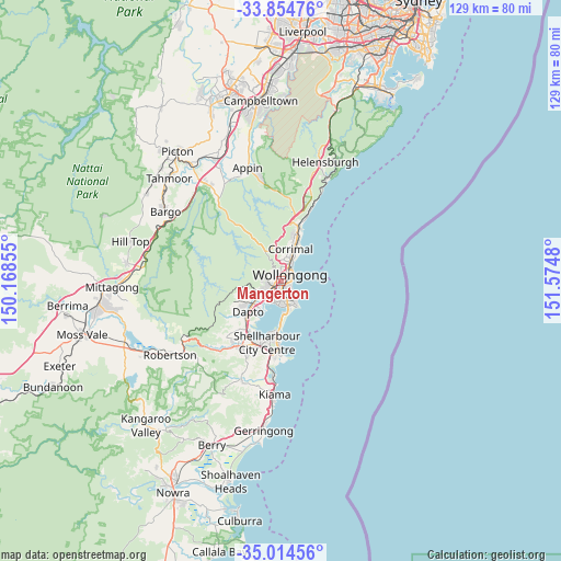
Mangerton GPS coordinates[2]
34° 26' 12.012" South, 150° 52' 18.012" East
| Map corner | latitude | longitude |
|---|---|---|
| Upper-left | -33.85476°, | 150.16855° |
| Center: | -34.43667°, | 150.87167° |
| Lower-right: | -35.01456°, | 151.5748° |
| Map W x H: | 129×129 km | = 80.2×80.2mi |
| max Lat: | -10.58257° ⇑62.7% North |
| Mangerton: | -34.43667° |
| min Lat: | ⇓37.3% South -43.31423° |
| min Long | Mangerton | max Long |
| 113.53327° | 150.87167° | 153.61246° |
| W 64.7%⇐ | ⇒35.3% E |
Elevation
Elevation of Mangerton is 37 m = 121 ft, and this is 85 m = 279 ft below average elevation for this country.
| Max E: |
1715 m = 5627 ft | 55.9% |
| Avg. | 122 m = 400 ft | |
| Mangerton | 37 m = 121 ft | |
Min E: |
-2 m = -7 ft | 44.1% |
See also: Australia elevation on elevation.city.
Geographical zone
Mangerton is located in South temperate zone (between Tropic of Capricorn and the Antarctic Circle). Distance of this Southern Tropic circle is 1223.1 km =760 mi to North.| Distance of | km | miles | from Mangerton |
|---|---|---|---|
| Equator | 3829 | 2379.2 | to North |
| Tropic Capricorn | 1223.1 | 760 | to North |
| Antarctic Circle | 3572.2 | 2219.7 | to South |
| South Pole | 6178.1 | 3838.9 | to South |


Nearby cities:
15 places around Mangerton: (largest is in red/bold)
• Balgownie
4.7 km =2.9 mi,  9°
9°
• Coniston
1.8 km =1.1 mi,  144°
144°
• Cordeaux Heights
3.2 km =2 mi,  262°
262°
• Cringila
3.9 km =2.4 mi,  185°
185°
• Figtree
1.2 km =0.7 mi,  275°
275°
• Gwynneville
2.7 km =1.7 mi,  33°
33°
• Keiraville
2.3 km =1.4 mi,  348°
348°
• Mount Ousley
4.1 km =2.5 mi,  21°
21°
• Mount Pleasant
4.6 km =2.9 mi, 354°
• Mount Saint Thomas
0.7 km =0.4 mi,  176°
176°
• North Wollongong
4.2 km =2.6 mi, 34°
• Unanderra
2.9 km =1.8 mi,  230°
230°
• West Wollongong
1.5 km =0.9 mi,  332°
332°
• Wollongong
2.4 km =1.5 mi,  54°
54°
• Wollongong city centre
2.2 km =1.4 mi,  63°
63°
Sources, notices
• [Note1] Compared only with cities in Australia existing in our database
• [Src1] Map data: © OpenStreetMap contributors (CC-BY-SA)
• [Src2] Other city data from geonames.org with taken over terms of usage.
• [Src3] Geographical zone / Annual Mean Temperature by Robert A. Rohde @ Wikipedia
