Belmont geodata
Belmont (Victoria) is a section of populated place; located in Australia in Australia/Melbourne (GMT+11) time zone. With population of 13,767 people, there are 324 cities with bigger population in this country. Compared to other cities in Australia, 93.8% of cities are located further ↑North; 71% of cities are located further →East and 51.7% of cities have higher elevation than Belmont. Note1


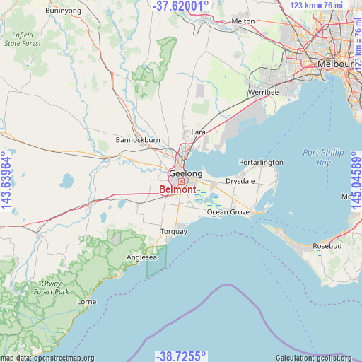
Belmont GPS coordinates[2]
38° 10' 29.46" South, 144° 20' 33.936" East
| Map corner | latitude | longitude |
|---|---|---|
| Upper-left | -37.62001°, | 143.63964° |
| Center: | -38.17485°, | 144.34276° |
| Lower-right: | -38.7255°, | 145.04589° |
| Map W x H: | 122.9×122.9 km | = 76.4×76.4mi |
| max Lat: | -10.58257° ⇑93.8% North |
| Belmont: | -38.17485° |
| min Lat: | ⇓6.2% South -43.31423° |
| min Long | Belmont | max Long |
| 113.53327° | 144.34276° | 153.61246° |
| W 29%⇐ | ⇒71% E |
Elevation
Elevation of Belmont is 43 m = 141 ft, and this is 79 m = 259 ft below average elevation for this country.
| Max E: |
1715 m = 5627 ft | 51.7% |
| Avg. | 122 m = 400 ft | |
| Belmont | 43 m = 141 ft | |
Min E: |
-2 m = -7 ft | 48.3% |
See also: Australia elevation on elevation.city.
Geographical zone
Belmont is located in South temperate zone (between Tropic of Capricorn and the Antarctic Circle). Distance of this Southern Tropic circle is 1638.7 km =1018.2 mi to North.| Distance of | km | miles | from Belmont |
|---|---|---|---|
| Equator | 4244.6 | 2637.5 | to North |
| Tropic Capricorn | 1638.7 | 1018.2 | to North |
| Antarctic Circle | 3156.5 | 1961.4 | to South |
| South Pole | 5762.4 | 3580.6 | to South |


Nearby cities:
15 places around Belmont: (largest is in red/bold)
• Breakwater
2.2 km =1.4 mi,  104°
104°
• East Geelong
3.3 km =2.1 mi,  50°
50°
• Geelong
3.5 km =2.2 mi,  26°
26°
• Geelong West
4 km =2.5 mi,  7°
7°
• Geelong city centre
3.2 km =2 mi, 30°
• Grovedale
2.9 km =1.8 mi,  167°
167°
• Highton
2.8 km =1.7 mi,  279°
279°
• Manifold Heights
4.2 km =2.6 mi,  349°
349°
• Newcomb
4.6 km =2.9 mi,  77°
77°
• Newtown
2.4 km =1.5 mi,  343°
343°
• South Geelong
1.8 km =1.1 mi,  37°
37°
• St Albans Park
4.6 km =2.9 mi,  108°
108°
• Thomson
3.2 km =2 mi, 79°
• Wandana Heights
3.4 km =2.1 mi,  268°
268°
• Whittington
4.5 km =2.8 mi, 98°
Sources, notices
• [Note1] Compared only with cities in Australia existing in our database
• [Src1] Map data: © OpenStreetMap contributors (CC-BY-SA)
• [Src2] Other city data from geonames.org with taken over terms of usage.
• [Src3] Geographical zone / Annual Mean Temperature by Robert A. Rohde @ Wikipedia
