Newtown geodata
Newtown (Victoria) is a section of populated place; located in Australia in Australia/Melbourne (GMT+11) time zone. With population of 9,827 people, there are 617 cities with bigger population in this country. Compared to other cities in Australia, 93.4% of cities are located further ↑North; 71% of cities are located further →East and 56.9% of cities have lower elevation than Newtown. Note1


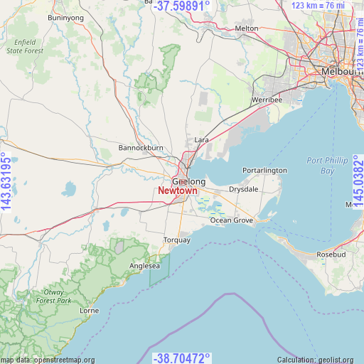
Newtown GPS coordinates[2]
38° 9' 14.076" South, 144° 20' 6.252" East
| Map corner | latitude | longitude |
|---|---|---|
| Upper-left | -37.59891°, | 143.63195° |
| Center: | -38.15391°, | 144.33507° |
| Lower-right: | -38.70472°, | 145.0382° |
| Map W x H: | 123×123 km | = 76.4×76.4mi |
| max Lat: | -10.58257° ⇑93.4% North |
| Newtown: | -38.15391° |
| min Lat: | ⇓6.6% South -43.31423° |
| min Long | Newtown | max Long |
| 113.53327° | 144.33507° | 153.61246° |
| W 29%⇐ | ⇒71% E |
Elevation
Elevation of Newtown is 57 m = 187 ft, and this is 65 m = 213 ft below average elevation for this country.
| Max E: |
1715 m = 5627 ft | 43.1% |
| Avg. | 122 m = 400 ft | |
| Newtown | 57 m = 187 ft | |
Min E: |
-2 m = -7 ft | 56.9% |
See also: Australia elevation on elevation.city.
Geographical zone
Newtown is located in South temperate zone (between Tropic of Capricorn and the Antarctic Circle). Distance of this Southern Tropic circle is 1636.4 km =1016.8 mi to North.| Distance of | km | miles | from Newtown |
|---|---|---|---|
| Equator | 4242.3 | 2636 | to North |
| Tropic Capricorn | 1636.4 | 1016.8 | to North |
| Antarctic Circle | 3158.9 | 1962.8 | to South |
| South Pole | 5764.7 | 3582 | to South |


Nearby cities:
15 places around Newtown: (largest is in red/bold)
• Belmont
2.4 km =1.5 mi,  163°
163°
• Breakwater
4.1 km =2.5 mi,  135°
135°
• Drumcondra
3.1 km =1.9 mi,  31°
31°
• East Geelong
3.2 km =2 mi,  93°
93°
• Geelong
2.4 km =1.5 mi,  71°
71°
• Geelong West
2 km =1.2 mi, 34°
• Geelong city centre
2.4 km =1.5 mi,  79°
79°
• Hamlyn Heights
3.7 km =2.3 mi,  350°
350°
• Herne Hill
2.4 km =1.5 mi,  336°
336°
• Highton
2.8 km =1.7 mi,  228°
228°
• Manifold Heights
1.8 km =1.1 mi,  356°
356°
• Rippleside
3.6 km =2.2 mi, 29°
• South Geelong
2 km =1.2 mi,  116°
116°
• Thomson
4.2 km =2.6 mi,  114°
114°
• Wandana Heights
3.7 km =2.3 mi, 228°
Sources, notices
• [Note1] Compared only with cities in Australia existing in our database
• [Src1] Map data: © OpenStreetMap contributors (CC-BY-SA)
• [Src2] Other city data from geonames.org with taken over terms of usage.
• [Src3] Geographical zone / Annual Mean Temperature by Robert A. Rohde @ Wikipedia
