Ayr geodata
Ayr (Queensland) is a populated place; located in Australia in Australia/Brisbane (GMT+10) time zone. With population of 8,818 people, there are 721 cities with bigger population in this country. Compared to other cities in Australia, 94.7% of cities are located further ↓South; 50.2% of cities are located further →East and 80.4% of cities have higher elevation than Ayr. Note1


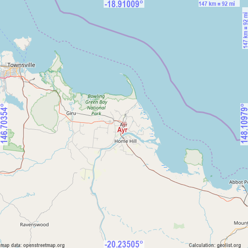
Ayr GPS coordinates[2]
19° 34' 26.148" South, 147° 24' 23.976" East
| Map corner | latitude | longitude |
|---|---|---|
| Upper-left | -18.91009°, | 146.70354° |
| Center: | -19.57393°, | 147.40666° |
| Lower-right: | -20.23505°, | 148.10979° |
| Map W x H: | 147.3×147.3 km | = 91.5×91.5mi |
| max Lat: | -10.58257° ⇑5.3% North |
| Ayr: | -19.57393° |
| min Lat: | ⇓94.7% South -43.31423° |
| min Long | Ayr | max Long |
| 113.53327° | 147.40666° | 153.61246° |
| W 49.8%⇐ | ⇒50.2% E |
Elevation
Elevation of Ayr is 15 m = 49 ft, and this is 107 m = 351 ft below average elevation for this country.
| Max E: |
1715 m = 5627 ft | 80.4% |
| Avg. | 122 m = 400 ft | |
| Ayr | 15 m = 49 ft | |
Min E: |
-2 m = -7 ft | 19.6% |
See also: Australia elevation on elevation.city.
Geographical zone
Ayr is located in South Torrid zone (between Equator and Tropic of Capricorn). Distance of this Southern Tropic circle is 429.5 km =266.9 mi to South.| Distance of | km | miles | from Ayr |
|---|---|---|---|
| Equator | 2176.4 | 1352.4 | to North |
| Tropic Capricorn | 429.5 | 266.9 | to South |
| Antarctic Circle | 5224.8 | 3246.5 | to South |
| South Pole | 7830.6 | 4865.7 | to South |


Nearby cities:
15 places around Ayr: (largest is in red/bold)
• Alligator Creek
53.2 km =33.1 mi,  292°
292°
• Annandale
70.7 km =43.9 mi, 294°
• Brandon
6 km =3.7 mi, 291°
• Cluden
67.3 km =41.8 mi,  295°
295°
• Hermit Park
71.1 km =44.2 mi, 296°
• Home Hill
9.5 km =5.9 mi,  176°
176°
• Idalia
68.9 km =42.8 mi, 295°
• Murray
70.2 km =43.6 mi, 293°
• Nome
53.6 km =33.3 mi, 295°
• Oonoonba
68.7 km =42.7 mi, 296°
• Railway Estate
69.9 km =43.4 mi, 298°
• Rosslea
70.8 km =44 mi, 295°
• South Townsville
69.2 km =43 mi, 299°
• Stuart
64.2 km =39.9 mi, 293°
• Wulguru
67.4 km =41.9 mi, 293°
Sources, notices
• [Note1] Compared only with cities in Australia existing in our database
• [Src1] Map data: © OpenStreetMap contributors (CC-BY-SA)
• [Src2] Other city data from geonames.org with taken over terms of usage.
• [Src3] Geographical zone / Annual Mean Temperature by Robert A. Rohde @ Wikipedia
