Aspley geodata
Aspley (Queensland) is a section of populated place; located in Australia in Australia/Brisbane (GMT+10) time zone. With population of 12,000 people, there are 414 cities with bigger population in this country. Compared to other cities in Australia, 84.1% of cities are located further ↓South; 91.8% of cities are located further ←West and 63.7% of cities have higher elevation than Aspley. Note1


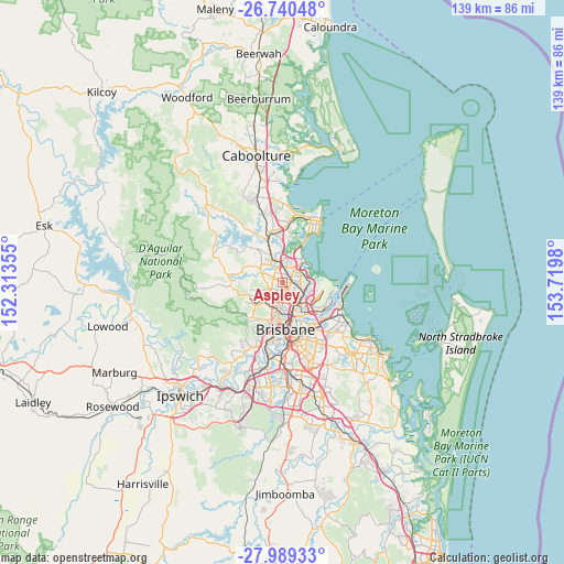
Aspley GPS coordinates[2]
27° 22' 0.012" South, 153° 1' 0.012" East
| Map corner | latitude | longitude |
|---|---|---|
| Upper-left | -26.74048°, | 152.31355° |
| Center: | -27.36667°, | 153.01667° |
| Lower-right: | -27.98933°, | 153.7198° |
| Map W x H: | 138.9×138.9 km | = 86.3×86.3mi |
| max Lat: | -10.58257° ⇑15.9% North |
| Aspley: | -27.36667° |
| min Lat: | ⇓84.1% South -43.31423° |
| min Long | Aspley | max Long |
| 113.53327° | 153.01667° | 153.61246° |
| W 91.8%⇐ | ⇒8.2% E |
Elevation
Elevation of Aspley is 28 m = 92 ft, and this is 94 m = 308 ft below average elevation for this country.
| Max E: |
1715 m = 5627 ft | 63.7% |
| Avg. | 122 m = 400 ft | |
| Aspley | 28 m = 92 ft | |
Min E: |
-2 m = -7 ft | 36.3% |
See also: Australia elevation on elevation.city.
Geographical zone
Aspley is located in South temperate zone (between Tropic of Capricorn and the Antarctic Circle). Distance of this Southern Tropic circle is 437 km =271.5 mi to North.| Distance of | km | miles | from Aspley |
|---|---|---|---|
| Equator | 3042.9 | 1890.8 | to North |
| Tropic Capricorn | 437 | 271.5 | to North |
| Antarctic Circle | 4358.3 | 2708.1 | to South |
| South Pole | 6964.2 | 4327.4 | to South |


Nearby cities:
15 places around Aspley: (largest is in red/bold)
• Albany Creek
5 km =3.1 mi,  286°
286°
• Boondall
4.6 km =2.9 mi,  71°
71°
• Bridgeman Downs
2.5 km =1.6 mi,  299°
299°
• Carseldine
2.2 km =1.4 mi,  16°
16°
• Chermside
2.4 km =1.5 mi,  145°
145°
• Chermside West
1.9 km =1.2 mi,  182°
182°
• Fitzgibbon
3.2 km =2 mi, 22°
• Geebung
3.1 km =1.9 mi,  102°
102°
• Kedron
4.2 km =2.6 mi,  162°
162°
• McDowall
3 km =1.9 mi,  233°
233°
• Stafford
4.9 km =3 mi,  186°
186°
• Stafford Heights
3 km =1.9 mi, 191°
• Taigum
3.8 km =2.4 mi,  45°
45°
• Wavell Heights
4.3 km =2.7 mi,  135°
135°
• Zillmere
3 km =1.9 mi, 66°
Sources, notices
• [Note1] Compared only with cities in Australia existing in our database
• [Src1] Map data: © OpenStreetMap contributors (CC-BY-SA)
• [Src2] Other city data from geonames.org with taken over terms of usage.
• [Src3] Geographical zone / Annual Mean Temperature by Robert A. Rohde @ Wikipedia
