Stafford geodata
Stafford (Queensland) is a section of populated place; located in Australia in Australia/Brisbane (GMT+10) time zone. With population of 6,423 people, there are 1095 cities with bigger population in this country. Compared to other cities in Australia, 83.6% of cities are located further ↓South; 91.5% of cities are located further ←West and 68.6% of cities have higher elevation than Stafford. Note1


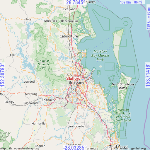
Stafford GPS coordinates[2]
27° 24' 37.584" South, 153° 0' 39.78" East
| Map corner | latitude | longitude |
|---|---|---|
| Upper-left | -26.7845°, | 152.30793° |
| Center: | -27.41044°, | 153.01105° |
| Lower-right: | -28.03285°, | 153.71418° |
| Map W x H: | 138.8×138.8 km | = 86.2×86.2mi |
| max Lat: | -10.58257° ⇑16.4% North |
| Stafford: | -27.41044° |
| min Lat: | ⇓83.6% South -43.31423° |
| min Long | Stafford | max Long |
| 113.53327° | 153.01105° | 153.61246° |
| W 91.5%⇐ | ⇒8.5% E |
Elevation
Elevation of Stafford is 24 m = 79 ft, and this is 98 m = 322 ft below average elevation for this country.
| Max E: |
1715 m = 5627 ft | 68.6% |
| Avg. | 122 m = 400 ft | |
| Stafford | 24 m = 79 ft | |
Min E: |
-2 m = -7 ft | 31.4% |
See also: Australia elevation on elevation.city.
Geographical zone
Stafford is located in South temperate zone (between Tropic of Capricorn and the Antarctic Circle). Distance of this Southern Tropic circle is 441.8 km =274.5 mi to North.| Distance of | km | miles | from Stafford |
|---|---|---|---|
| Equator | 3047.8 | 1893.8 | to North |
| Tropic Capricorn | 441.8 | 274.5 | to North |
| Antarctic Circle | 4353.4 | 2705.1 | to South |
| South Pole | 6959.3 | 4324.3 | to South |


Nearby cities:
15 places around Stafford: (largest is in red/bold)
• Alderley
1.9 km =1.2 mi,  210°
210°
• Chermside
3.5 km =2.2 mi,  34°
34°
• Chermside West
3 km =1.9 mi,  9°
9°
• Everton Park
2.3 km =1.4 mi,  278°
278°
• Gaythorne
2.8 km =1.7 mi,  255°
255°
• Gordon Park
1.7 km =1.1 mi,  123°
123°
• Grange
1.4 km =0.9 mi,  162°
162°
• Kedron
2 km =1.2 mi,  65°
65°
• Lutwyche
2.6 km =1.6 mi, 121°
• McDowall
3.6 km =2.2 mi,  328°
328°
• Newmarket
2.8 km =1.7 mi,  186°
186°
• Stafford Heights
1.9 km =1.2 mi,  358°
358°
• Wilston
2.5 km =1.6 mi, 161°
• Windsor
3.4 km =2.1 mi,  148°
148°
• Wooloowin
3.3 km =2.1 mi,  113°
113°
Sources, notices
• [Note1] Compared only with cities in Australia existing in our database
• [Src1] Map data: © OpenStreetMap contributors (CC-BY-SA)
• [Src2] Other city data from geonames.org with taken over terms of usage.
• [Src3] Geographical zone / Annual Mean Temperature by Robert A. Rohde @ Wikipedia
