Ascot geodata
Ascot (Victoria) is a populated place; located in Australia in Australia/Melbourne (GMT+11) time zone. With population of 1,926 people, there are 2954 cities with bigger population in this country. Compared to other cities in Australia, 80.4% of cities are located further ↑North; 71.1% of cities are located further →East and 81.2% of cities have lower elevation than Ascot. Note1


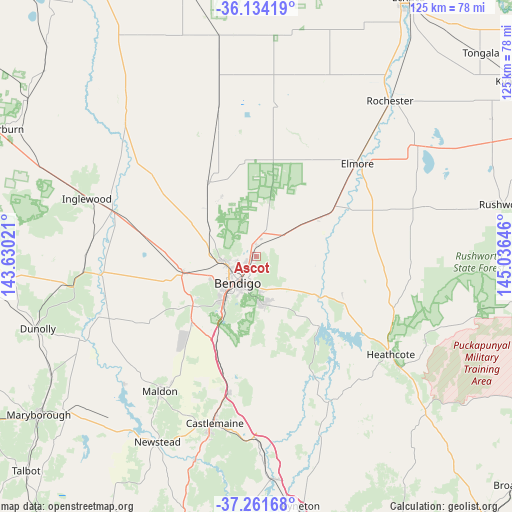
Ascot GPS coordinates[2]
36° 42' 0" South, 144° 19' 59.988" East
| Map corner | latitude | longitude |
|---|---|---|
| Upper-left | -36.13419°, | 143.63021° |
| Center: | -36.7°, | 144.33333° |
| Lower-right: | -37.26168°, | 145.03646° |
| Map W x H: | 125.4×125.4 km | = 77.9×77.9mi |
| max Lat: | -10.58257° ⇑80.4% North |
| Ascot: | -36.7° |
| min Lat: | ⇓19.6% South -43.31423° |
| min Long | Ascot | max Long |
| 113.53327° | 144.33333° | 153.61246° |
| W 28.9%⇐ | ⇒71.1% E |
Elevation
Elevation of Ascot is 194 m = 636 ft, and this is 72 m = 236 ft above average elevation for this country.
| Max E: |
1715 m = 5627 ft | 18.8% |
| Ascot | 194 m 636 ft | |
| Avg. | 122 m = 400 ft | |
Min E: |
-2 m = -7 ft | 81.2% |
See also: Australia elevation on elevation.city.
Geographical zone
Ascot is located in South temperate zone (between Tropic of Capricorn and the Antarctic Circle). Distance of this Southern Tropic circle is 1474.7 km =916.3 mi to North.| Distance of | km | miles | from Ascot |
|---|---|---|---|
| Equator | 4080.7 | 2535.6 | to North |
| Tropic Capricorn | 1474.7 | 916.3 | to North |
| Antarctic Circle | 3320.5 | 2063.3 | to South |
| South Pole | 5926.4 | 3682.5 | to South |


Nearby cities:
15 places around Ascot: (largest is in red/bold)
• Bendigo
8 km =5 mi,  216°
216°
• Bendigo city centre
7.9 km =4.9 mi, 217°
• California Gully
7.2 km =4.5 mi,  243°
243°
• Eaglehawk
7.6 km =4.7 mi,  256°
256°
• East Bendigo
4.8 km =3 mi,  195°
195°
• Epsom
2.4 km =1.5 mi, 218°
• Huntly
3.9 km =2.4 mi,  0°
0°
• Ironbark
8.7 km =5.4 mi,  225°
225°
• Jackass Flat
4.6 km =2.9 mi,  247°
247°
• Junortoun
8.3 km =5.2 mi,  161°
161°
• Kennington
8.4 km =5.2 mi, 198°
• Long Gully
8.3 km =5.2 mi, 234°
• North Bendigo
6.3 km =3.9 mi, 219°
• Strathdale
7.5 km =4.7 mi,  192°
192°
• White Hills
4.1 km =2.5 mi, 218°
Sources, notices
• [Note1] Compared only with cities in Australia existing in our database
• [Src1] Map data: © OpenStreetMap contributors (CC-BY-SA)
• [Src2] Other city data from geonames.org with taken over terms of usage.
• [Src3] Geographical zone / Annual Mean Temperature by Robert A. Rohde @ Wikipedia
