Bundeena geodata
Bundeena (New South Wales) is a section of populated place; located in Australia in Australia/Sydney (GMT+10) time zone. With population of 1,860 people, there are 3000 cities with bigger population in this country. Compared to other cities in Australia, 60.6% of cities are located further ↑North; 71.8% of cities are located further ←West and 93.8% of cities have higher elevation than Bundeena. Note1


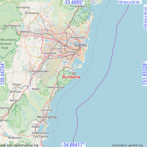
Bundeena GPS coordinates[2]
34° 5' 1.824" South, 151° 9' 0.576" East
| Map corner | latitude | longitude |
|---|---|---|
| Upper-left | -33.4995°, | 150.44704° |
| Center: | -34.08384°, | 151.15016° |
| Lower-right: | -34.66417°, | 151.85329° |
| Map W x H: | 129.5×129.5 km | = 80.5×80.5mi |
| max Lat: | -10.58257° ⇑60.6% North |
| Bundeena: | -34.08384° |
| min Lat: | ⇓39.4% South -43.31423° |
| min Long | Bundeena | max Long |
| 113.53327° | 151.15016° | 153.61246° |
| W 71.8%⇐ | ⇒28.2% E |
Elevation
Elevation of Bundeena is 7 m = 23 ft, and this is 115 m = 377 ft below average elevation for this country.
| Max E: |
1715 m = 5627 ft | 93.8% |
| Avg. | 122 m = 400 ft | |
| Bundeena | 7 m = 23 ft | |
Min E: |
-2 m = -7 ft | 6.2% |
See also: Australia elevation on elevation.city.
Geographical zone
Bundeena is located in South temperate zone (between Tropic of Capricorn and the Antarctic Circle). Distance of this Southern Tropic circle is 1183.8 km =735.6 mi to North.| Distance of | km | miles | from Bundeena |
|---|---|---|---|
| Equator | 3789.8 | 2354.9 | to North |
| Tropic Capricorn | 1183.8 | 735.6 | to North |
| Antarctic Circle | 3611.4 | 2244 | to South |
| South Pole | 6217.3 | 3863.2 | to South |


Nearby cities:
15 places around Bundeena: (largest is in red/bold)
• Burraneer
3.3 km =2.1 mi,  340°
340°
• Caringbah
5.9 km =3.7 mi, 336°
• Caringbah South
4 km =2.5 mi,  318°
318°
• Cronulla
2.4 km =1.5 mi,  358°
358°
• Dolans Bay
2.8 km =1.7 mi,  313°
313°
• Grays Point
6.5 km =4 mi,  295°
295°
• Greenhills Beach
5.3 km =3.3 mi,  8°
8°
• Gymea
8 km =5 mi, 311°
• Gymea Bay
6.7 km =4.2 mi, 301°
• Lilli Pilli
3.6 km =2.2 mi, 298°
• Miranda
6.8 km =4.2 mi, 317°
• Port Hacking
2.9 km =1.8 mi, 308°
• Taren Point
7.7 km =4.8 mi, 337°
• Woolooware
4.3 km =2.7 mi,  351°
351°
• Yowie Bay
5.7 km =3.5 mi, 309°
Sources, notices
• [Note1] Compared only with cities in Australia existing in our database
• [Src1] Map data: © OpenStreetMap contributors (CC-BY-SA)
• [Src2] Other city data from geonames.org with taken over terms of usage.
• [Src3] Geographical zone / Annual Mean Temperature by Robert A. Rohde @ Wikipedia
