Gymea geodata
Gymea (New South Wales) is a section of populated place; located in Australia in Australia/Sydney (GMT+10) time zone. With population of 7,489 people, there are 905 cities with bigger population in this country. Compared to other cities in Australia, 59.7% of cities are located further ↑North; 69.5% of cities are located further ←West and 62.1% of cities have lower elevation than Gymea. Note1


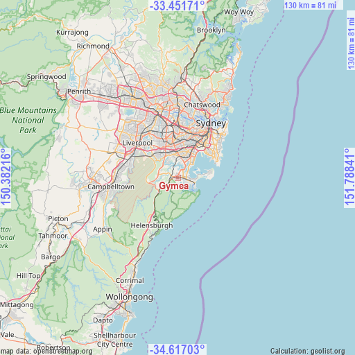
Gymea GPS coordinates[2]
34° 2' 10.932" South, 151° 5' 7.008" East
| Map corner | latitude | longitude |
|---|---|---|
| Upper-left | -33.45171°, | 150.38216° |
| Center: | -34.03637°, | 151.08528° |
| Lower-right: | -34.61703°, | 151.78841° |
| Map W x H: | 129.6×129.6 km | = 80.5×80.5mi |
| max Lat: | -10.58257° ⇑59.7% North |
| Gymea: | -34.03637° |
| min Lat: | ⇓40.3% South -43.31423° |
| min Long | Gymea | max Long |
| 113.53327° | 151.08528° | 153.61246° |
| W 69.5%⇐ | ⇒30.5% E |
Elevation
Elevation of Gymea is 70 m = 230 ft, and this is 52 m = 171 ft below average elevation for this country.
| Max E: |
1715 m = 5627 ft | 37.9% |
| Avg. | 122 m = 400 ft | |
| Gymea | 70 m = 230 ft | |
Min E: |
-2 m = -7 ft | 62.1% |
See also: Australia elevation on elevation.city.
Geographical zone
Gymea is located in South temperate zone (between Tropic of Capricorn and the Antarctic Circle). Distance of this Southern Tropic circle is 1178.6 km =732.3 mi to North.| Distance of | km | miles | from Gymea |
|---|---|---|---|
| Equator | 3784.5 | 2351.6 | to North |
| Tropic Capricorn | 1178.6 | 732.3 | to North |
| Antarctic Circle | 3616.7 | 2247.3 | to South |
| South Pole | 6222.6 | 3866.5 | to South |


Nearby cities:
15 places around Gymea: (largest is in red/bold)
• Caringbah
3.6 km =2.2 mi,  88°
88°
• Grays Point
2.5 km =1.6 mi,  178°
178°
• Gymea Bay
1.8 km =1.1 mi,  171°
171°
• Jannali
3.2 km =2 mi,  314°
314°
• Kangaroo Point
3.9 km =2.4 mi,  14°
14°
• Kareela
2.6 km =1.6 mi,  356°
356°
• Kirrawee
1.5 km =0.9 mi,  261°
261°
• Loftus
3.7 km =2.3 mi, 255°
• Miranda
1.4 km =0.9 mi,  100°
100°
• Oyster Bay
3.7 km =2.3 mi,  346°
346°
• Sutherland
2.8 km =1.7 mi,  282°
282°
• Sylvania
2.9 km =1.8 mi,  22°
22°
• Sylvania Waters
2.9 km =1.8 mi,  47°
47°
• Taren Point
3.6 km =2.2 mi,  58°
58°
• Yowie Bay
2.3 km =1.4 mi,  136°
136°
Sources, notices
• [Note1] Compared only with cities in Australia existing in our database
• [Src1] Map data: © OpenStreetMap contributors (CC-BY-SA)
• [Src2] Other city data from geonames.org with taken over terms of usage.
• [Src3] Geographical zone / Annual Mean Temperature by Robert A. Rohde @ Wikipedia
