Tarrawanna geodata
Tarrawanna (New South Wales) is a section of populated place; located in Australia in Australia/Sydney (GMT+11) time zone. With population of 2,050 people, there are 2867 cities with bigger population in this country. Compared to other cities in Australia, 62.2% of cities are located further ↑North; 65.1% of cities are located further ←West and 74.7% of cities have higher elevation than Tarrawanna. Note1


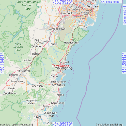
Tarrawanna GPS coordinates[2]
34° 22' 53.472" South, 150° 53' 16.764" East
| Map corner | latitude | longitude |
|---|---|---|
| Upper-left | -33.79923°, | 150.18487° |
| Center: | -34.38152°, | 150.88799° |
| Lower-right: | -34.95979°, | 151.59112° |
| Map W x H: | 129×129 km | = 80.2×80.2mi |
| max Lat: | -10.58257° ⇑62.2% North |
| Tarrawanna: | -34.38152° |
| min Lat: | ⇓37.8% South -43.31423° |
| min Long | Tarrawanna | max Long |
| 113.53327° | 150.88799° | 153.61246° |
| W 65.1%⇐ | ⇒34.9% E |
Elevation
Elevation of Tarrawanna is 19 m = 62 ft, and this is 103 m = 338 ft below average elevation for this country.
| Max E: |
1715 m = 5627 ft | 74.7% |
| Avg. | 122 m = 400 ft | |
| Tarrawanna | 19 m = 62 ft | |
Min E: |
-2 m = -7 ft | 25.3% |
See also: Australia elevation on elevation.city.
Geographical zone
Tarrawanna is located in South temperate zone (between Tropic of Capricorn and the Antarctic Circle). Distance of this Southern Tropic circle is 1216.9 km =756.1 mi to North.| Distance of | km | miles | from Tarrawanna |
|---|---|---|---|
| Equator | 3822.9 | 2375.4 | to North |
| Tropic Capricorn | 1216.9 | 756.1 | to North |
| Antarctic Circle | 3578.3 | 2223.5 | to South |
| South Pole | 6184.2 | 3842.7 | to South |


Nearby cities:
15 places around Tarrawanna: (largest is in red/bold)
• Balgownie
1.7 km =1.1 mi,  204°
204°
• Bellambi
3.1 km =1.9 mi,  57°
57°
• Corrimal
1.5 km =0.9 mi,  77°
77°
• East Corrimal
2.2 km =1.4 mi,  73°
73°
• Fairy Meadow
1.4 km =0.9 mi,  161°
161°
• Fern Hill
0.3 km =0.2 mi,  233°
233°
• Gwynneville
3.9 km =2.4 mi,  180°
180°
• Keiraville
4.4 km =2.7 mi,  206°
206°
• Mount Keira
3.7 km =2.3 mi,  242°
242°
• Mount Ousley
2.3 km =1.4 mi, 180°
• Mount Pleasant
2.5 km =1.6 mi, 232°
• North Wollongong
2.8 km =1.7 mi, 161°
• Russell Vale
3 km =1.9 mi,  11°
11°
• Towradgi
1.5 km =0.9 mi,  112°
112°
• Woonona
4.3 km =2.7 mi,  34°
34°
Sources, notices
• [Note1] Compared only with cities in Australia existing in our database
• [Src1] Map data: © OpenStreetMap contributors (CC-BY-SA)
• [Src2] Other city data from geonames.org with taken over terms of usage.
• [Src3] Geographical zone / Annual Mean Temperature by Robert A. Rohde @ Wikipedia
