Keiraville geodata
Keiraville (New South Wales) is a section of populated place; located in Australia in Australia/Sydney (GMT+11) time zone. With population of 3,613 people, there are 1951 cities with bigger population in this country. Compared to other cities in Australia, 62.5% of cities are located further ↑North; 64.4% of cities are located further ←West and 57.4% of cities have lower elevation than Keiraville. Note1


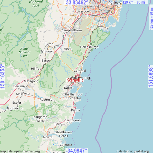
Keiraville GPS coordinates[2]
34° 25' 0.012" South, 150° 52' 0.012" East
| Map corner | latitude | longitude |
|---|---|---|
| Upper-left | -33.83462°, | 150.16355° |
| Center: | -34.41667°, | 150.86667° |
| Lower-right: | -34.9947°, | 151.5698° |
| Map W x H: | 129×129 km | = 80.2×80.2mi |
| max Lat: | -10.58257° ⇑62.5% North |
| Keiraville: | -34.41667° |
| min Lat: | ⇓37.5% South -43.31423° |
| min Long | Keiraville | max Long |
| 113.53327° | 150.86667° | 153.61246° |
| W 64.4%⇐ | ⇒35.6% E |
Elevation
Elevation of Keiraville is 58 m = 190 ft, and this is 64 m = 210 ft below average elevation for this country.
| Max E: |
1715 m = 5627 ft | 42.6% |
| Avg. | 122 m = 400 ft | |
| Keiraville | 58 m = 190 ft | |
Min E: |
-2 m = -7 ft | 57.4% |
See also: Australia elevation on elevation.city.
Geographical zone
Keiraville is located in South temperate zone (between Tropic of Capricorn and the Antarctic Circle). Distance of this Southern Tropic circle is 1220.9 km =758.6 mi to North.| Distance of | km | miles | from Keiraville |
|---|---|---|---|
| Equator | 3826.8 | 2377.9 | to North |
| Tropic Capricorn | 1220.9 | 758.6 | to North |
| Antarctic Circle | 3574.4 | 2221 | to South |
| South Pole | 6180.3 | 3840.3 | to South |


Nearby cities:
15 places around Keiraville: (largest is in red/bold)
• Balgownie
2.7 km =1.7 mi,  27°
27°
• Coniston
4 km =2.5 mi,  157°
157°
• Cordeaux Heights
3.8 km =2.4 mi,  225°
225°
• Fairy Meadow
3.6 km =2.2 mi,  42°
42°
• Figtree
2.2 km =1.4 mi,  200°
200°
• Gwynneville
1.9 km =1.2 mi,  90°
90°
• Mangerton
2.3 km =1.4 mi,  168°
168°
• Mount Keira
2.6 km =1.6 mi,  329°
329°
• Mount Ousley
2.5 km =1.6 mi,  50°
50°
• Mount Pleasant
2.4 km =1.5 mi,  359°
359°
• Mount Saint Thomas
3 km =1.9 mi, 170°
• North Wollongong
3.1 km =1.9 mi,  66°
66°
• West Wollongong
0.9 km =0.6 mi,  194°
194°
• Wollongong
2.6 km =1.6 mi,  108°
108°
• Wollongong city centre
2.7 km =1.7 mi,  117°
117°
Sources, notices
• [Note1] Compared only with cities in Australia existing in our database
• [Src1] Map data: © OpenStreetMap contributors (CC-BY-SA)
• [Src2] Other city data from geonames.org with taken over terms of usage.
• [Src3] Geographical zone / Annual Mean Temperature by Robert A. Rohde @ Wikipedia
