Brookvale geodata
Brookvale (New South Wales) is a section of populated place; located in Australia in Australia/Sydney (GMT+11) time zone. With population of 3,127 people, there are 2165 cities with bigger population in this country. Compared to other cities in Australia, 50.6% of cities are located further ↑North; 75.2% of cities are located further ←West and 64.8% of cities have higher elevation than Brookvale. Note1


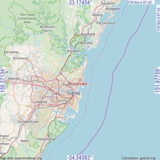
Brookvale GPS coordinates[2]
33° 45' 39.888" South, 151° 16' 28.056" East
| Map corner | latitude | longitude |
|---|---|---|
| Upper-left | -33.17454°, | 150.57134° |
| Center: | -33.76108°, | 151.27446° |
| Lower-right: | -34.34363°, | 151.97759° |
| Map W x H: | 130×130 km | = 80.8×80.8mi |
| max Lat: | -10.58257° ⇑50.6% North |
| Brookvale: | -33.76108° |
| min Lat: | ⇓49.4% South -43.31423° |
| min Long | Brookvale | max Long |
| 113.53327° | 151.27446° | 153.61246° |
| W 75.2%⇐ | ⇒24.8% E |
Elevation
Elevation of Brookvale is 27 m = 89 ft, and this is 95 m = 312 ft below average elevation for this country.
| Max E: |
1715 m = 5627 ft | 64.8% |
| Avg. | 122 m = 400 ft | |
| Brookvale | 27 m = 89 ft | |
Min E: |
-2 m = -7 ft | 35.2% |
See also: Australia elevation on elevation.city.
Geographical zone
Brookvale is located in South temperate zone (between Tropic of Capricorn and the Antarctic Circle). Distance of this Southern Tropic circle is 1148 km =713.3 mi to North.| Distance of | km | miles | from Brookvale |
|---|---|---|---|
| Equator | 3753.9 | 2332.6 | to North |
| Tropic Capricorn | 1148 | 713.3 | to North |
| Antarctic Circle | 3647.3 | 2266.3 | to South |
| South Pole | 6253.2 | 3885.6 | to South |


Nearby cities:
15 places around Brookvale: (largest is in red/bold)
• Allambie Heights
2.4 km =1.5 mi,  255°
255°
• Beacon Hill
1.7 km =1.1 mi,  302°
302°
• Collaroy Plateau
3.9 km =2.4 mi,  22°
22°
• Cromer
3.4 km =2.1 mi,  349°
349°
• Curl Curl
1.6 km =1 mi,  122°
122°
• Dee Why
1.7 km =1.1 mi,  50°
50°
• Fairlight
3.9 km =2.4 mi,  181°
181°
• Freshwater
2.2 km =1.4 mi,  152°
152°
• Manly Vale
2.9 km =1.8 mi,  203°
203°
• Narraweena
0.7 km =0.4 mi, 16°
• North Balgowlah
3.7 km =2.3 mi,  221°
221°
• North Curl Curl
2.1 km =1.3 mi,  99°
99°
• North Manly
1.7 km =1.1 mi, 196°
• Queenscliff
2.6 km =1.6 mi,  158°
158°
• Wheeler Heights
3.4 km =2.1 mi,  9°
9°
Sources, notices
• [Note1] Compared only with cities in Australia existing in our database
• [Src1] Map data: © OpenStreetMap contributors (CC-BY-SA)
• [Src2] Other city data from geonames.org with taken over terms of usage.
• [Src3] Geographical zone / Annual Mean Temperature by Robert A. Rohde @ Wikipedia
